You are here: Home > Network List > N4 - Central and EAstern US Network Stations List
> Station T57A Hurt, VA, USA > Earthquake Result Viewer
T57A Hurt, VA, USA - Earthquake Result Viewer
| Earthquake location: |
Andreanof Islands, Aleutian Is. |
| Earthquake latitude/longitude: |
51.1/-177.0 |
| Earthquake time(UTC): |
2017/05/08 (128) 15:31:28 GMT |
| Earthquake Depth: |
41 km |
| Earthquake Magnitude: |
5.5 Ml |
| Earthquake Catalog/Contributor: |
NEIC PDE/ak |
|
| Network: |
N4 Central and EAstern US Network |
| Station: |
T57A Hurt, VA, USA |
| Lat/Lon: |
37.00 N/79.25 W |
| Elevation: |
230 m |
|
| Distance: |
66.6 deg |
| Az: |
59.784 deg |
| Baz: |
317.076 deg |
| Ray Param: |
0.057410907 |
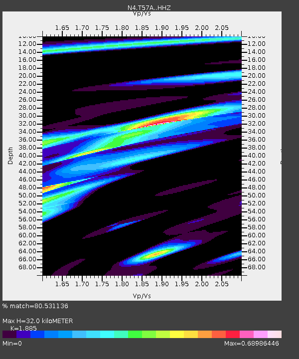
| Estimated Moho Depth: |
32.0 km |
| Estimated Crust Vp/Vs: |
1.88 |
| Assumed Crust Vp: |
6.419 km/s |
| Estimated Crust Vs: |
3.405 km/s |
| Estimated Crust Poisson's Ratio: |
0.30 |
|
| Radial Match: |
80.531136 % |
| Radial Bump: |
303 |
| Transverse Match: |
55.60921 % |
| Transverse Bump: |
349 |
| SOD ConfigId: |
11737051 |
| Insert Time: |
2019-04-27 07:14:09.353 +0000 |
| GWidth: |
2.5 |
| Max Bumps: |
400 |
| Tol: |
0.001 |
|

Signal To Noise
| Channel | StoN | STA | LTA |
| N4:T57A: :HHZ:20170508T15:41:44.940004Z | 6.005111 | 9.116775E-7 | 1.5181692E-7 |
| N4:T57A: :HHN:20170508T15:41:44.940004Z | 2.840291 | 3.385146E-7 | 1.1918307E-7 |
| N4:T57A: :HHE:20170508T15:41:44.940004Z | 1.6275308 | 2.0453649E-7 | 1.2567288E-7 |
| Arrivals |
| Ps | 4.6 SECOND |
| PpPs | 14 SECOND |
| PsPs/PpSs | 18 SECOND |


