You are here: Home > Network List > TA - USArray Transportable Network (new EarthScope stations) Stations List
> Station 226B Tecolote Peak, Malaga, NM, USA > Earthquake Result Viewer
226B Tecolote Peak, Malaga, NM, USA - Earthquake Result Viewer
| Earthquake location: |
Tonga Islands Region |
| Earthquake latitude/longitude: |
-23.0/-174.7 |
| Earthquake time(UTC): |
2009/03/19 (078) 18:17:40 GMT |
| Earthquake Depth: |
34 km |
| Earthquake Magnitude: |
7.0 MB, 7.6 MS, 7.6 MW, 7.6 MW |
| Earthquake Catalog/Contributor: |
WHDF/NEIC |
|
| Network: |
TA USArray Transportable Network (new EarthScope stations) |
| Station: |
226B Tecolote Peak, Malaga, NM, USA |
| Lat/Lon: |
32.08 N/104.17 W |
| Elevation: |
981 m |
|
| Distance: |
86.8 deg |
| Az: |
53.267 deg |
| Baz: |
240.412 deg |
| Ray Param: |
0.043724738 |
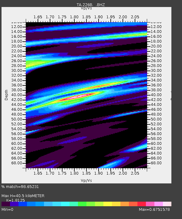
| Estimated Moho Depth: |
40.5 km |
| Estimated Crust Vp/Vs: |
1.81 |
| Assumed Crust Vp: |
6.232 km/s |
| Estimated Crust Vs: |
3.438 km/s |
| Estimated Crust Poisson's Ratio: |
0.28 |
|
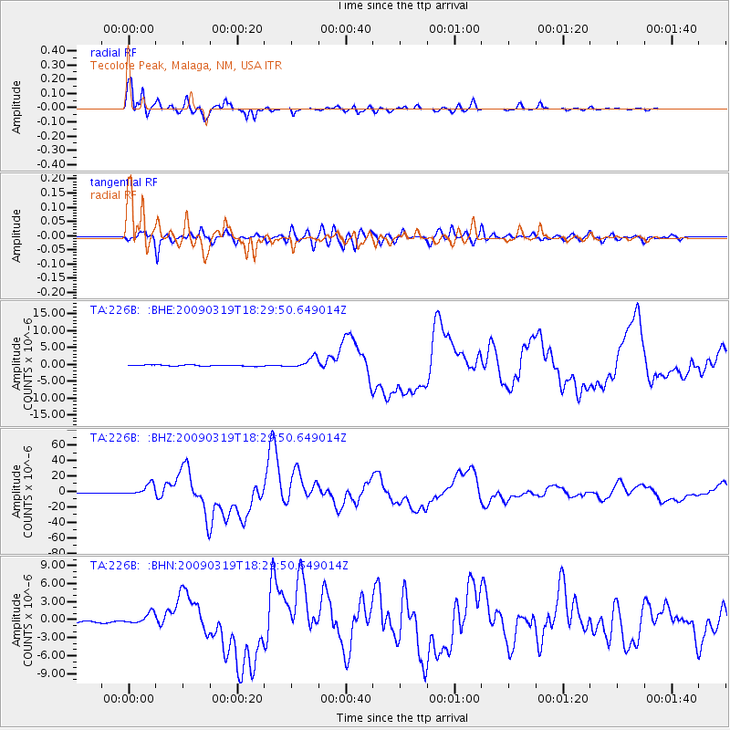
| Radial Match: |
98.65231 % |
| Radial Bump: |
366 |
| Transverse Match: |
90.08065 % |
| Transverse Bump: |
400 |
| SOD ConfigId: |
2658 |
| Insert Time: |
2010-03-05 23:38:02.902 +0000 |
| GWidth: |
2.5 |
| Max Bumps: |
400 |
| Tol: |
0.001 |
|
Signal To Noise
| Channel | StoN | STA | LTA |
| TA:226B: :BHZ:20090319T18:29:50.649014Z | 27.816341 | 7.5101752E-6 | 2.699915E-7 |
| TA:226B: :BHN:20090319T18:29:50.649014Z | 10.982836 | 9.489033E-7 | 8.639875E-8 |
| TA:226B: :BHE:20090319T18:29:50.649014Z | 9.713853 | 1.6153974E-6 | 1.6629832E-7 |
| Arrivals |
| Ps | 5.4 SECOND |
| PpPs | 18 SECOND |
| PsPs/PpSs | 23 SECOND |


