You are here: Home > Network List > TA - USArray Transportable Network (new EarthScope stations) Stations List
> Station 226B Tecolote Peak, Malaga, NM, USA > Earthquake Result Viewer
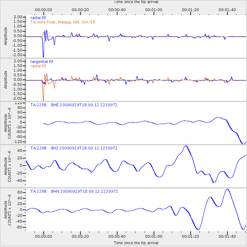
226B Tecolote Peak, Malaga, NM, USA - Earthquake Result Viewer
*The percent match for this event was below the threshold and hence no stack was calculated.
| Earthquake location: |
Tonga Islands |
| Earthquake latitude/longitude: |
-15.8/-173.1 |
| Earthquake time(UTC): |
2009/09/29 (272) 17:57:26 GMT |
| Earthquake Depth: |
10 km |
| Earthquake Magnitude: |
5.6 MB |
| Earthquake Catalog/Contributor: |
WHDF/NEIC |
|
| Network: |
TA USArray Transportable Network (new EarthScope stations) |
| Station: |
226B Tecolote Peak, Malaga, NM, USA |
| Lat/Lon: |
32.08 N/104.17 W |
| Elevation: |
981 m |
|
| Distance: |
81.4 deg |
| Az: |
53.266 deg |
| Baz: |
245.334 deg |
| Ray Param: |
$rayparam |
*The percent match for this event was below the threshold and hence was not used in the summary stack. |
|
| Radial Match: |
93.15365 % |
| Radial Bump: |
328 |
| Transverse Match: |
71.04574 % |
| Transverse Bump: |
269 |
| SOD ConfigId: |
2622 |
| Insert Time: |
2010-03-05 23:38:25.388 +0000 |
| GWidth: |
2.5 |
| Max Bumps: |
400 |
| Tol: |
0.001 |
|
Signal To Noise
| Channel | StoN | STA | LTA |
| TA:226B: :BHZ:20090929T18:09:12.223997Z | 0.3173993 | 4.1896174E-6 | 1.3199832E-5 |
| TA:226B: :BHN:20090929T18:09:12.223997Z | 1.2525824 | 6.387506E-6 | 5.0994695E-6 |
| TA:226B: :BHE:20090929T18:09:12.223997Z | 1.5597842 | 8.870956E-6 | 5.687297E-6 |
| Arrivals |
| Ps | |
| PpPs | |
| PsPs/PpSs | |


