You are here: Home > Network List > TA - USArray Transportable Network (new EarthScope stations) Stations List
> Station 226B Tecolote Peak, Malaga, NM, USA > Earthquake Result Viewer
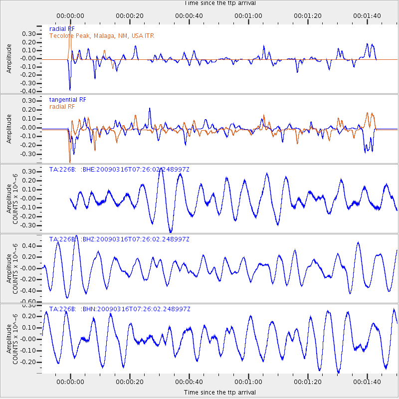
226B Tecolote Peak, Malaga, NM, USA - Earthquake Result Viewer
*The percent match for this event was below the threshold and hence no stack was calculated.
| Earthquake location: |
Pacific-Antarctic Ridge |
| Earthquake latitude/longitude: |
-55.1/-129.7 |
| Earthquake time(UTC): |
2009/03/16 (075) 07:13:36 GMT |
| Earthquake Depth: |
10 km |
| Earthquake Magnitude: |
5.9 MW, 5.2 MS, 5.1 MB, 5.9 MW |
| Earthquake Catalog/Contributor: |
WHDF/NEIC |
|
| Network: |
TA USArray Transportable Network (new EarthScope stations) |
| Station: |
226B Tecolote Peak, Malaga, NM, USA |
| Lat/Lon: |
32.08 N/104.17 W |
| Elevation: |
981 m |
|
| Distance: |
89.6 deg |
| Az: |
21.466 deg |
| Baz: |
194.328 deg |
| Ray Param: |
$rayparam |
*The percent match for this event was below the threshold and hence was not used in the summary stack. |
|
| Radial Match: |
67.43786 % |
| Radial Bump: |
400 |
| Transverse Match: |
48.820324 % |
| Transverse Bump: |
386 |
| SOD ConfigId: |
2658 |
| Insert Time: |
2010-03-05 23:38:39.422 +0000 |
| GWidth: |
2.5 |
| Max Bumps: |
400 |
| Tol: |
0.001 |
|
Signal To Noise
| Channel | StoN | STA | LTA |
| TA:226B: :BHZ:20090316T07:26:02.248997Z | 2.7580843 | 3.7842844E-7 | 1.3720698E-7 |
| TA:226B: :BHN:20090316T07:26:02.248997Z | 0.79271775 | 9.903901E-8 | 1.2493604E-7 |
| TA:226B: :BHE:20090316T07:26:02.248997Z | 4.067831 | 2.5905456E-7 | 6.368371E-8 |
| Arrivals |
| Ps | |
| PpPs | |
| PsPs/PpSs | |


