You are here: Home > Network List > TA - USArray Transportable Network (new EarthScope stations) Stations List
> Station 530A J-C Ranch, Comstock, TX, USA > Earthquake Result Viewer
530A J-C Ranch, Comstock, TX, USA - Earthquake Result Viewer
| Earthquake location: |
Near Coast Of Venezuela |
| Earthquake latitude/longitude: |
10.7/-67.9 |
| Earthquake time(UTC): |
2009/09/12 (255) 20:06:24 GMT |
| Earthquake Depth: |
10 km |
| Earthquake Magnitude: |
6.3 MB, 6.4 MS, 6.3 MW, 6.3 MW |
| Earthquake Catalog/Contributor: |
WHDF/NEIC |
|
| Network: |
TA USArray Transportable Network (new EarthScope stations) |
| Station: |
530A J-C Ranch, Comstock, TX, USA |
| Lat/Lon: |
30.15 N/101.34 W |
| Elevation: |
636 m |
|
| Distance: |
36.6 deg |
| Az: |
306.865 deg |
| Baz: |
114.799 deg |
| Ray Param: |
0.07659084 |
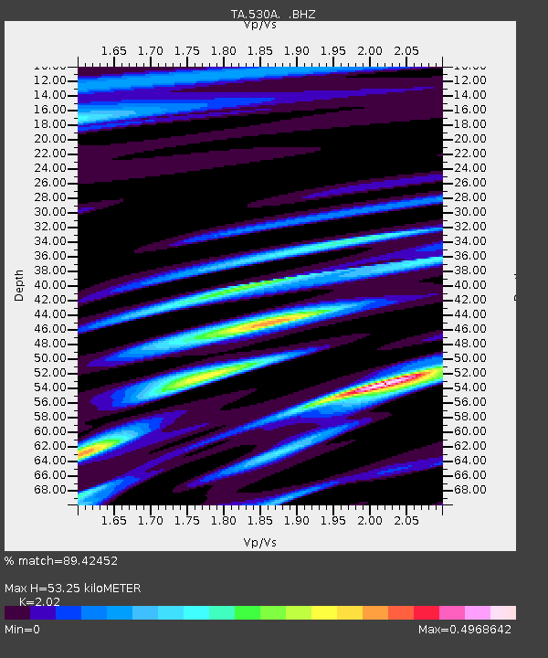
| Estimated Moho Depth: |
53.25 km |
| Estimated Crust Vp/Vs: |
2.02 |
| Assumed Crust Vp: |
6.38 km/s |
| Estimated Crust Vs: |
3.159 km/s |
| Estimated Crust Poisson's Ratio: |
0.34 |
|
| Radial Match: |
89.42452 % |
| Radial Bump: |
307 |
| Transverse Match: |
70.67811 % |
| Transverse Bump: |
400 |
| SOD ConfigId: |
2622 |
| Insert Time: |
2010-03-05 23:38:57.905 +0000 |
| GWidth: |
2.5 |
| Max Bumps: |
400 |
| Tol: |
0.001 |
|

Signal To Noise
| Channel | StoN | STA | LTA |
| TA:530A: :BHZ:20090912T20:13:00.073992Z | 9.508561 | 9.938085E-7 | 1.04517234E-7 |
| TA:530A: :BHN:20090912T20:13:00.073992Z | 3.6600194 | 3.1630162E-7 | 8.6420755E-8 |
| TA:530A: :BHE:20090912T20:13:00.073992Z | 10.049449 | 5.902086E-7 | 5.873044E-8 |
| Arrivals |
| Ps | 9.1 SECOND |
| PpPs | 24 SECOND |
| PsPs/PpSs | 33 SECOND |


