You are here: Home > Network List > TA - USArray Transportable Network (new EarthScope stations) Stations List
> Station 530A J-C Ranch, Comstock, TX, USA > Earthquake Result Viewer
530A J-C Ranch, Comstock, TX, USA - Earthquake Result Viewer
| Earthquake location: |
Easter Island Region |
| Earthquake latitude/longitude: |
-29.1/-112.3 |
| Earthquake time(UTC): |
2009/09/17 (260) 23:21:38 GMT |
| Earthquake Depth: |
10 km |
| Earthquake Magnitude: |
5.7 MB, 6.0 MS, 6.2 MW, 6.2 MW |
| Earthquake Catalog/Contributor: |
WHDF/NEIC |
|
| Network: |
TA USArray Transportable Network (new EarthScope stations) |
| Station: |
530A J-C Ranch, Comstock, TX, USA |
| Lat/Lon: |
30.15 N/101.34 W |
| Elevation: |
636 m |
|
| Distance: |
59.9 deg |
| Az: |
10.945 deg |
| Baz: |
191.055 deg |
| Ray Param: |
0.061900232 |
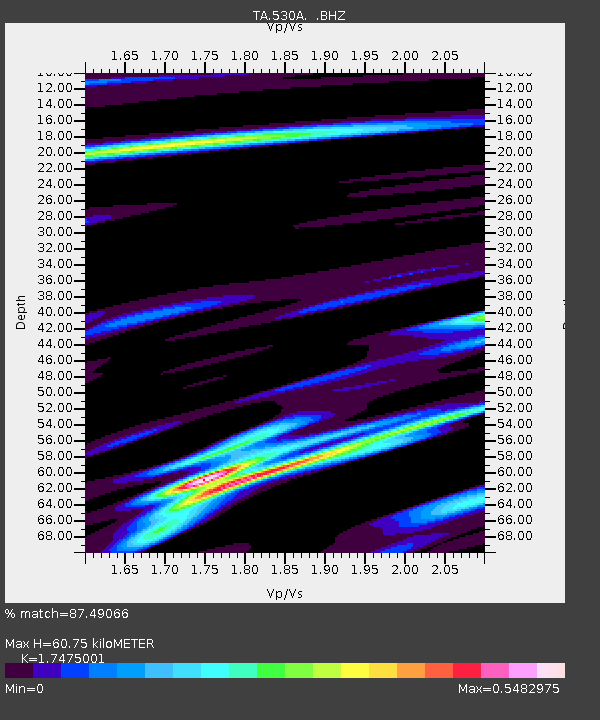
| Estimated Moho Depth: |
60.75 km |
| Estimated Crust Vp/Vs: |
1.75 |
| Assumed Crust Vp: |
6.38 km/s |
| Estimated Crust Vs: |
3.651 km/s |
| Estimated Crust Poisson's Ratio: |
0.26 |
|
| Radial Match: |
87.49066 % |
| Radial Bump: |
269 |
| Transverse Match: |
57.517582 % |
| Transverse Bump: |
400 |
| SOD ConfigId: |
2622 |
| Insert Time: |
2010-03-05 23:39:01.370 +0000 |
| GWidth: |
2.5 |
| Max Bumps: |
400 |
| Tol: |
0.001 |
|

Signal To Noise
| Channel | StoN | STA | LTA |
| TA:530A: :BHZ:20090917T23:31:13.225017Z | 1.9287919 | 3.5812278E-7 | 1.8567206E-7 |
| TA:530A: :BHN:20090917T23:31:13.225017Z | 1.2523046 | 1.3295494E-7 | 1.06168216E-7 |
| TA:530A: :BHE:20090917T23:31:13.225017Z | 0.7381129 | 1.0680901E-7 | 1.4470551E-7 |
| Arrivals |
| Ps | 7.5 SECOND |
| PpPs | 25 SECOND |
| PsPs/PpSs | 32 SECOND |


