You are here: Home > Network List > TA - USArray Transportable Network (new EarthScope stations) Stations List
> Station 530A J-C Ranch, Comstock, TX, USA > Earthquake Result Viewer
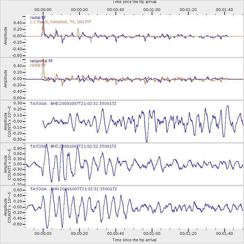
530A J-C Ranch, Comstock, TX, USA - Earthquake Result Viewer
| Earthquake location: |
East Of Severnaya Zemlya |
| Earthquake latitude/longitude: |
81.6/119.5 |
| Earthquake time(UTC): |
2009/10/07 (280) 20:52:13 GMT |
| Earthquake Depth: |
8.0 km |
| Earthquake Magnitude: |
5.7 MB, 5.1 MS, 5.8 MW, 5.8 MW |
| Earthquake Catalog/Contributor: |
WHDF/NEIC |
|
| Network: |
TA USArray Transportable Network (new EarthScope stations) |
| Station: |
530A J-C Ranch, Comstock, TX, USA |
| Lat/Lon: |
30.15 N/101.34 W |
| Elevation: |
636 m |
|
| Distance: |
66.6 deg |
| Az: |
38.15 deg |
| Baz: |
353.96 deg |
| Ray Param: |
0.057533313 |
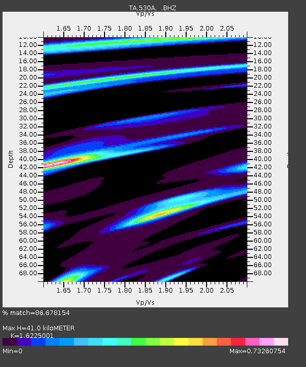
| Estimated Moho Depth: |
41.0 km |
| Estimated Crust Vp/Vs: |
1.62 |
| Assumed Crust Vp: |
6.38 km/s |
| Estimated Crust Vs: |
3.933 km/s |
| Estimated Crust Poisson's Ratio: |
0.19 |
|
| Radial Match: |
86.678154 % |
| Radial Bump: |
327 |
| Transverse Match: |
71.68042 % |
| Transverse Bump: |
400 |
| SOD ConfigId: |
2622 |
| Insert Time: |
2010-03-05 23:39:08.861 +0000 |
| GWidth: |
2.5 |
| Max Bumps: |
400 |
| Tol: |
0.001 |
|
Signal To Noise
| Channel | StoN | STA | LTA |
| TA:530A: :BHZ:20091007T21:02:32.350017Z | 7.528809 | 6.946852E-7 | 9.227026E-8 |
| TA:530A: :BHN:20091007T21:02:32.350017Z | 5.7104955 | 4.2980608E-7 | 7.526598E-8 |
| TA:530A: :BHE:20091007T21:02:32.350017Z | 2.182023 | 1.2221908E-7 | 5.6011817E-8 |
| Arrivals |
| Ps | 4.2 SECOND |
| PpPs | 16 SECOND |
| PsPs/PpSs | 20 SECOND |


