You are here: Home > Network List > IU - Global Seismograph Network (GSN - IRIS/USGS) Stations List
> Station POHA Pohakuloa, Hawaii, USA > Earthquake Result Viewer
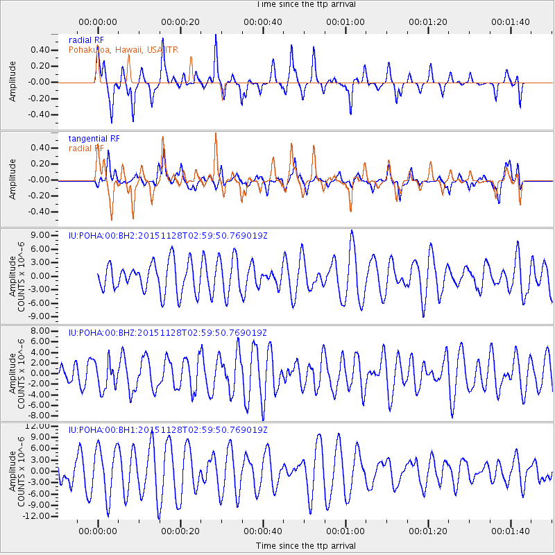
POHA Pohakuloa, Hawaii, USA - Earthquake Result Viewer
*The percent match for this event was below the threshold and hence no stack was calculated.
| Earthquake location: |
Kuril Islands |
| Earthquake latitude/longitude: |
43.3/146.5 |
| Earthquake time(UTC): |
2015/11/28 (332) 02:51:06 GMT |
| Earthquake Depth: |
60 km |
| Earthquake Magnitude: |
5.9 MB |
| Earthquake Catalog/Contributor: |
NEIC PDE/NEIC COMCAT |
|
| Network: |
IU Global Seismograph Network (GSN - IRIS/USGS) |
| Station: |
POHA Pohakuloa, Hawaii, USA |
| Lat/Lon: |
19.76 N/155.53 W |
| Elevation: |
1990 m |
|
| Distance: |
53.6 deg |
| Az: |
96.878 deg |
| Baz: |
309.733 deg |
| Ray Param: |
$rayparam |
*The percent match for this event was below the threshold and hence was not used in the summary stack. |
|
| Radial Match: |
60.551067 % |
| Radial Bump: |
306 |
| Transverse Match: |
44.503075 % |
| Transverse Bump: |
357 |
| SOD ConfigId: |
1259291 |
| Insert Time: |
2015-12-12 03:41:33.218 +0000 |
| GWidth: |
2.5 |
| Max Bumps: |
400 |
| Tol: |
0.001 |
|
Signal To Noise
| Channel | StoN | STA | LTA |
| IU:POHA:00:BHZ:20151128T02:59:50.769019Z | 1.0356766 | 2.5779639E-6 | 2.4891592E-6 |
| IU:POHA:00:BH1:20151128T02:59:50.769019Z | 1.7989043 | 6.60223E-6 | 3.6701397E-6 |
| IU:POHA:00:BH2:20151128T02:59:50.769019Z | 1.3438147 | 4.30732E-6 | 3.205293E-6 |
| Arrivals |
| Ps | |
| PpPs | |
| PsPs/PpSs | |


