You are here: Home > Network List > TA - USArray Transportable Network (new EarthScope stations) Stations List
> Station 530A J-C Ranch, Comstock, TX, USA > Earthquake Result Viewer
530A J-C Ranch, Comstock, TX, USA - Earthquake Result Viewer
| Earthquake location: |
South Of Tonga Islands |
| Earthquake latitude/longitude: |
-24.1/-175.2 |
| Earthquake time(UTC): |
2009/11/02 (306) 10:47:13 GMT |
| Earthquake Depth: |
9.0 km |
| Earthquake Magnitude: |
6.1 MB, 6.1 MS, 6.2 MW, 6.1 MW |
| Earthquake Catalog/Contributor: |
WHDF/NEIC |
|
| Network: |
TA USArray Transportable Network (new EarthScope stations) |
| Station: |
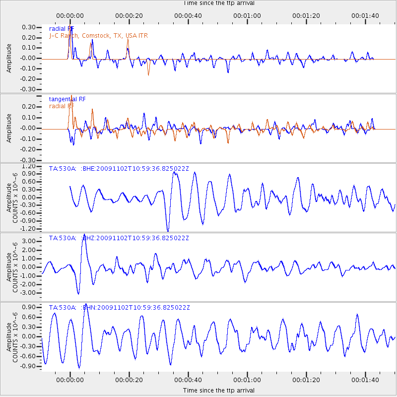
530A J-C Ranch, Comstock, TX, USA |
| Lat/Lon: |
30.15 N/101.34 W |
| Elevation: |
636 m |
|
| Distance: |
89.0 deg |
| Az: |
56.311 deg |
| Baz: |
241.367 deg |
| Ray Param: |
0.042162873 |
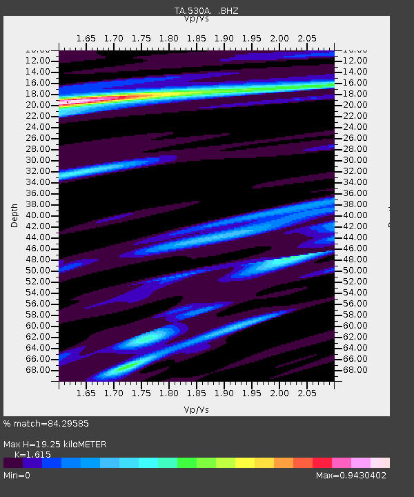
| Estimated Moho Depth: |
19.25 km |
| Estimated Crust Vp/Vs: |
1.62 |
| Assumed Crust Vp: |
6.38 km/s |
| Estimated Crust Vs: |
3.951 km/s |
| Estimated Crust Poisson's Ratio: |
0.19 |
|
| Radial Match: |
84.29585 % |
| Radial Bump: |
317 |
| Transverse Match: |
55.02115 % |
| Transverse Bump: |
325 |
| SOD ConfigId: |
2622 |
| Insert Time: |
2010-03-05 23:39:14.541 +0000 |
| GWidth: |
2.5 |
| Max Bumps: |
400 |
| Tol: |
0.001 |
|
Signal To Noise
| Channel | StoN | STA | LTA |
| TA:530A: :BHZ:20091102T10:59:36.825022Z | 5.6252413 | 1.8726433E-6 | 3.329001E-7 |
| TA:530A: :BHN:20091102T10:59:36.825022Z | 1.2039877 | 5.1765085E-7 | 4.2994694E-7 |
| TA:530A: :BHE:20091102T10:59:36.825022Z | 2.7551787 | 5.7913206E-7 | 2.1019764E-7 |
| Arrivals |
| Ps | 1.9 SECOND |
| PpPs | 7.7 SECOND |
| PsPs/PpSs | 9.6 SECOND |


