You are here: Home > Network List > IW - Intermountain West Stations List
> Station MOOW Moose Ponds, Wyoming, USA > Earthquake Result Viewer
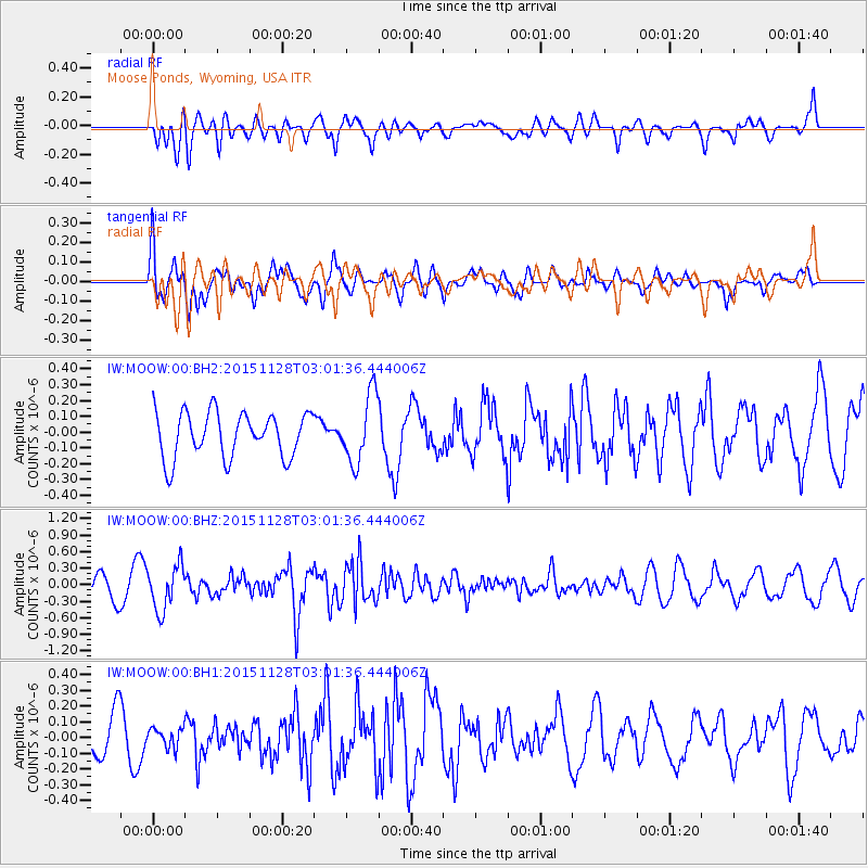
MOOW Moose Ponds, Wyoming, USA - Earthquake Result Viewer
*The percent match for this event was below the threshold and hence no stack was calculated.
| Earthquake location: |
Kuril Islands |
| Earthquake latitude/longitude: |
43.3/146.5 |
| Earthquake time(UTC): |
2015/11/28 (332) 02:51:06 GMT |
| Earthquake Depth: |
60 km |
| Earthquake Magnitude: |
5.9 MB |
| Earthquake Catalog/Contributor: |
NEIC PDE/NEIC COMCAT |
|
| Network: |
IW Intermountain West |
| Station: |
MOOW Moose Ponds, Wyoming, USA |
| Lat/Lon: |
43.75 N/110.74 W |
| Elevation: |
2128 m |
|
| Distance: |
69.2 deg |
| Az: |
49.097 deg |
| Baz: |
310.457 deg |
| Ray Param: |
$rayparam |
*The percent match for this event was below the threshold and hence was not used in the summary stack. |
|
| Radial Match: |
69.96807 % |
| Radial Bump: |
400 |
| Transverse Match: |
56.648758 % |
| Transverse Bump: |
400 |
| SOD ConfigId: |
1259291 |
| Insert Time: |
2015-12-12 03:42:09.896 +0000 |
| GWidth: |
2.5 |
| Max Bumps: |
400 |
| Tol: |
0.001 |
|
Signal To Noise
| Channel | StoN | STA | LTA |
| IW:MOOW:00:BHZ:20151128T03:01:36.444006Z | 2.0009775 | 4.071194E-7 | 2.0346025E-7 |
| IW:MOOW:00:BH1:20151128T03:01:36.444006Z | 0.557909 | 6.0868906E-8 | 1.0910186E-7 |
| IW:MOOW:00:BH2:20151128T03:01:36.444006Z | 1.5175949 | 2.162795E-7 | 1.4251464E-7 |
| Arrivals |
| Ps | |
| PpPs | |
| PsPs/PpSs | |


