You are here: Home > Network List > TA - USArray Transportable Network (new EarthScope stations) Stations List
> Station 530A J-C Ranch, Comstock, TX, USA > Earthquake Result Viewer
530A J-C Ranch, Comstock, TX, USA - Earthquake Result Viewer
| Earthquake location: |
West Chile Rise |
| Earthquake latitude/longitude: |
-41.7/-84.0 |
| Earthquake time(UTC): |
2009/06/10 (161) 23:13:21 GMT |
| Earthquake Depth: |
10 km |
| Earthquake Magnitude: |
5.7 MB, 5.2 MS, 5.7 MW, 5.6 MW |
| Earthquake Catalog/Contributor: |
WHDF/NEIC |
|
| Network: |
TA USArray Transportable Network (new EarthScope stations) |
| Station: |
530A J-C Ranch, Comstock, TX, USA |
| Lat/Lon: |
30.15 N/101.34 W |
| Elevation: |
636 m |
|
| Distance: |
73.3 deg |
| Az: |
344.36 deg |
| Baz: |
166.525 deg |
| Ray Param: |
0.053108767 |
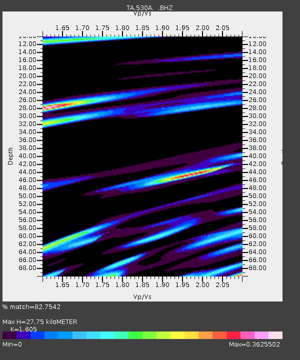
| Estimated Moho Depth: |
27.75 km |
| Estimated Crust Vp/Vs: |
1.61 |
| Assumed Crust Vp: |
6.38 km/s |
| Estimated Crust Vs: |
3.975 km/s |
| Estimated Crust Poisson's Ratio: |
0.18 |
|
| Radial Match: |
82.7542 % |
| Radial Bump: |
323 |
| Transverse Match: |
50.68034 % |
| Transverse Bump: |
359 |
| SOD ConfigId: |
2648 |
| Insert Time: |
2010-03-05 23:39:21.214 +0000 |
| GWidth: |
2.5 |
| Max Bumps: |
400 |
| Tol: |
0.001 |
|
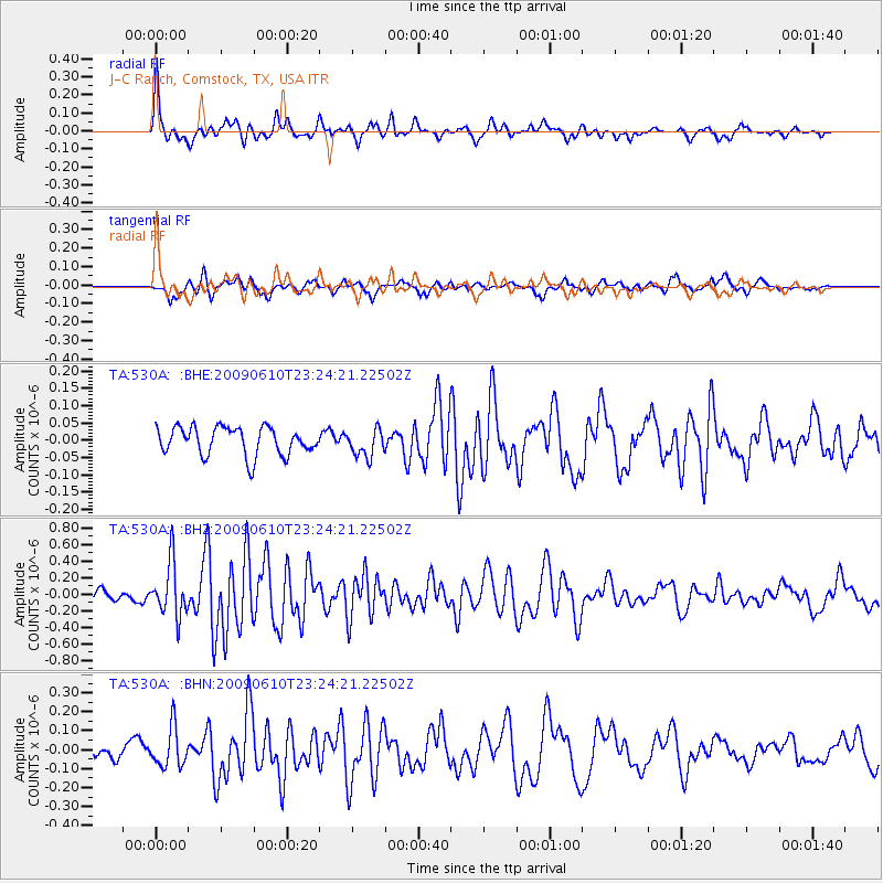
Signal To Noise
| Channel | StoN | STA | LTA |
| TA:530A: :BHZ:20090610T23:24:21.22502Z | 7.325296 | 3.230872E-7 | 4.4105686E-8 |
| TA:530A: :BHN:20090610T23:24:21.22502Z | 2.0102513 | 1.0271078E-7 | 5.1093505E-8 |
| TA:530A: :BHE:20090610T23:24:21.22502Z | 0.98271525 | 3.959132E-8 | 4.0287684E-8 |
| Arrivals |
| Ps | 2.7 SECOND |
| PpPs | 11 SECOND |
| PsPs/PpSs | 14 SECOND |


