You are here: Home > Network List > TA - USArray Transportable Network (new EarthScope stations) Stations List
> Station 530A J-C Ranch, Comstock, TX, USA > Earthquake Result Viewer
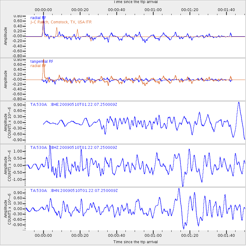
530A J-C Ranch, Comstock, TX, USA - Earthquake Result Viewer
| Earthquake location: |
Off Coast Of Ecuador |
| Earthquake latitude/longitude: |
1.4/-85.2 |
| Earthquake time(UTC): |
2009/05/10 (130) 01:16:06 GMT |
| Earthquake Depth: |
6.0 km |
| Earthquake Magnitude: |
5.5 MB, 5.7 MS, 6.1 MW, 6.1 MW |
| Earthquake Catalog/Contributor: |
WHDF/NEIC |
|
| Network: |
TA USArray Transportable Network (new EarthScope stations) |
| Station: |
530A J-C Ranch, Comstock, TX, USA |
| Lat/Lon: |
30.15 N/101.34 W |
| Elevation: |
636 m |
|
| Distance: |
32.5 deg |
| Az: |
333.296 deg |
| Baz: |
148.758 deg |
| Ray Param: |
0.07864927 |
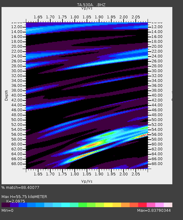
| Estimated Moho Depth: |
55.75 km |
| Estimated Crust Vp/Vs: |
2.10 |
| Assumed Crust Vp: |
6.38 km/s |
| Estimated Crust Vs: |
3.042 km/s |
| Estimated Crust Poisson's Ratio: |
0.35 |
|
| Radial Match: |
88.40077 % |
| Radial Bump: |
359 |
| Transverse Match: |
65.948586 % |
| Transverse Bump: |
351 |
| SOD ConfigId: |
2760 |
| Insert Time: |
2010-03-05 23:39:38.197 +0000 |
| GWidth: |
2.5 |
| Max Bumps: |
400 |
| Tol: |
0.001 |
|
Signal To Noise
| Channel | StoN | STA | LTA |
| TA:530A: :BHZ:20090510T01:22:07.250009Z | 3.6056511 | 5.6548447E-7 | 1.5683283E-7 |
| TA:530A: :BHN:20090510T01:22:07.250009Z | 3.0341866 | 2.5281398E-7 | 8.332184E-8 |
| TA:530A: :BHE:20090510T01:22:07.250009Z | 2.9985218 | 2.6225746E-7 | 8.7462254E-8 |
| Arrivals |
| Ps | 10 SECOND |
| PpPs | 25 SECOND |
| PsPs/PpSs | 36 SECOND |


