You are here: Home > Network List > TA - USArray Transportable Network (new EarthScope stations) Stations List
> Station MDND Maddock, ND, USA > Earthquake Result Viewer
MDND Maddock, ND, USA - Earthquake Result Viewer
| Earthquake location: |
Andreanof Islands, Aleutian Is. |
| Earthquake latitude/longitude: |
51.0/-177.1 |
| Earthquake time(UTC): |
2017/05/08 (128) 15:47:28 GMT |
| Earthquake Depth: |
1.0 km |
| Earthquake Magnitude: |
5.7 Mi |
| Earthquake Catalog/Contributor: |
NEIC PDE/at |
|
| Network: |
TA USArray Transportable Network (new EarthScope stations) |
| Station: |
MDND Maddock, ND, USA |
| Lat/Lon: |
47.85 N/99.60 W |
| Elevation: |
479 m |
|
| Distance: |
48.3 deg |
| Az: |
61.68 deg |
| Baz: |
304.248 deg |
| Ray Param: |
0.0694553 |
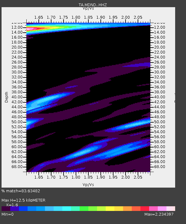
| Estimated Moho Depth: |
12.5 km |
| Estimated Crust Vp/Vs: |
1.60 |
| Assumed Crust Vp: |
6.53 km/s |
| Estimated Crust Vs: |
4.082 km/s |
| Estimated Crust Poisson's Ratio: |
0.18 |
|
| Radial Match: |
83.63482 % |
| Radial Bump: |
398 |
| Transverse Match: |
52.36287 % |
| Transverse Bump: |
294 |
| SOD ConfigId: |
11737051 |
| Insert Time: |
2019-04-27 07:30:50.098 +0000 |
| GWidth: |
2.5 |
| Max Bumps: |
400 |
| Tol: |
0.001 |
|
Signal To Noise
| Channel | StoN | STA | LTA |
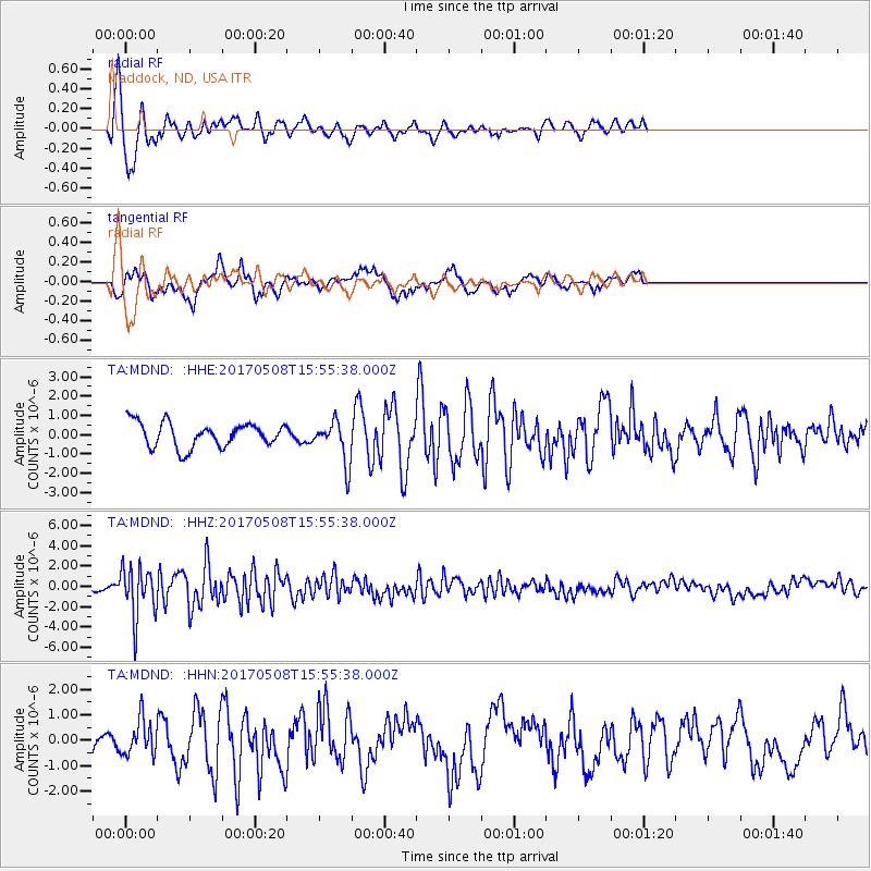
| TA:MDND: :HHZ:20170508T15:55:38.000Z | 7.23011 | 2.5097577E-6 | 3.471258E-7 |
| TA:MDND: :HHN:20170508T15:55:38.000Z | 1.4947437 | 7.0184336E-7 | 4.6954094E-7 |
| TA:MDND: :HHE:20170508T15:55:38.000Z | 2.5332046 | 1.4354799E-6 | 5.666656E-7 |
| Arrivals |
| Ps | 1.2 SECOND |
| PpPs | 4.6 SECOND |
| PsPs/PpSs | 5.9 SECOND |


