You are here: Home > Network List > NO - Norwegian Seismic Array Network Stations List
> Station SPB1 > Earthquake Result Viewer
SPB1 - Earthquake Result Viewer
| Earthquake location: |
Kuril Islands |
| Earthquake latitude/longitude: |
43.3/146.5 |
| Earthquake time(UTC): |
2015/11/28 (332) 02:51:06 GMT |
| Earthquake Depth: |
60 km |
| Earthquake Magnitude: |
5.9 MB |
| Earthquake Catalog/Contributor: |
NEIC PDE/NEIC COMCAT |
|
| Network: |
NO Norwegian Seismic Array Network |
| Station: |
SPB1 |
| Lat/Lon: |
78.18 N/16.39 E |
| Elevation: |
301 m |
|
| Distance: |
55.1 deg |
| Az: |
348.911 deg |
| Baz: |
42.893 deg |
| Ray Param: |
0.06486665 |
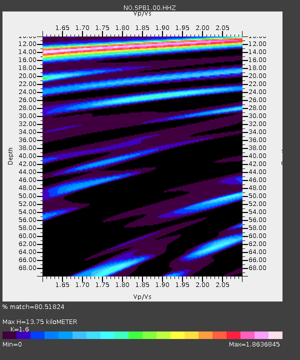
| Estimated Moho Depth: |
13.75 km |
| Estimated Crust Vp/Vs: |
1.60 |
| Assumed Crust Vp: |
6.545 km/s |
| Estimated Crust Vs: |
4.091 km/s |
| Estimated Crust Poisson's Ratio: |
0.18 |
|
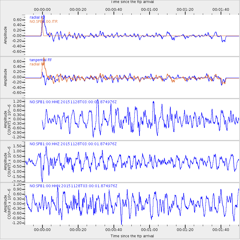
| Radial Match: |
80.51824 % |
| Radial Bump: |
400 |
| Transverse Match: |
45.989014 % |
| Transverse Bump: |
400 |
| SOD ConfigId: |
1259291 |
| Insert Time: |
2015-12-12 03:45:32.006 +0000 |
| GWidth: |
2.5 |
| Max Bumps: |
400 |
| Tol: |
0.001 |
|
Signal To Noise
| Channel | StoN | STA | LTA |
| NO:SPB1:00:HHZ:20151128T03:00:01.874976Z | 3.2226057 | 9.407881E-7 | 2.91934E-7 |
| NO:SPB1:00:HHN:20151128T03:00:01.874976Z | 0.8716784 | 3.0956542E-7 | 3.551372E-7 |
| NO:SPB1:00:HHE:20151128T03:00:01.874976Z | 2.0636232 | 7.2731063E-7 | 3.5244352E-7 |
| Arrivals |
| Ps | 1.3 SECOND |
| PpPs | 5.1 SECOND |
| PsPs/PpSs | 6.5 SECOND |


