You are here: Home > Network List > TA - USArray Transportable Network (new EarthScope stations) Stations List
> Station 230A Sterling City, TX, USA > Earthquake Result Viewer
230A Sterling City, TX, USA - Earthquake Result Viewer
| Earthquake location: |
Southeast Of Honshu, Japan |
| Earthquake latitude/longitude: |
32.8/140.4 |
| Earthquake time(UTC): |
2009/08/12 (224) 22:48:51 GMT |
| Earthquake Depth: |
53 km |
| Earthquake Magnitude: |
6.2 MB, 6.6 MW, 6.6 MW |
| Earthquake Catalog/Contributor: |
WHDF/NEIC |
|
| Network: |
TA USArray Transportable Network (new EarthScope stations) |
| Station: |
230A Sterling City, TX, USA |
| Lat/Lon: |
31.89 N/101.11 W |
| Elevation: |
742 m |
|
| Distance: |
93.3 deg |
| Az: |
48.495 deg |
| Baz: |
312.159 deg |
| Ray Param: |
0.041258484 |
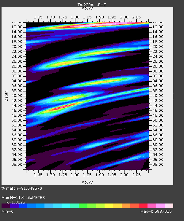
| Estimated Moho Depth: |
11.0 km |
| Estimated Crust Vp/Vs: |
1.88 |
| Assumed Crust Vp: |
6.38 km/s |
| Estimated Crust Vs: |
3.389 km/s |
| Estimated Crust Poisson's Ratio: |
0.30 |
|
| Radial Match: |
91.049576 % |
| Radial Bump: |
400 |
| Transverse Match: |
73.057655 % |
| Transverse Bump: |
400 |
| SOD ConfigId: |
2622 |
| Insert Time: |
2010-03-05 23:40:34.247 +0000 |
| GWidth: |
2.5 |
| Max Bumps: |
400 |
| Tol: |
0.001 |
|
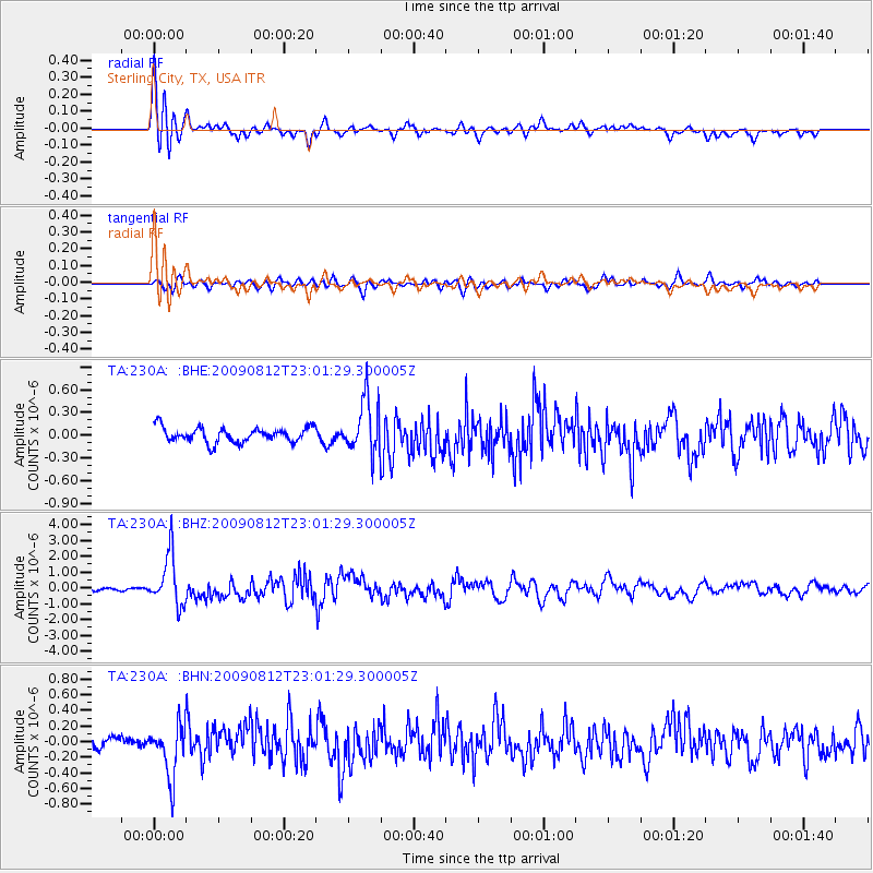
Signal To Noise
| Channel | StoN | STA | LTA |
| TA:230A: :BHZ:20090812T23:01:29.300005Z | 23.769217 | 1.5902098E-6 | 6.690206E-8 |
| TA:230A: :BHN:20090812T23:01:29.300005Z | 6.0057244 | 3.348761E-7 | 5.5759482E-8 |
| TA:230A: :BHE:20090812T23:01:29.300005Z | 3.6277409 | 3.5438995E-7 | 9.768888E-8 |
| Arrivals |
| Ps | 1.6 SECOND |
| PpPs | 4.9 SECOND |
| PsPs/PpSs | 6.4 SECOND |


