You are here: Home > Network List > TA - USArray Transportable Network (new EarthScope stations) Stations List
> Station 230A Sterling City, TX, USA > Earthquake Result Viewer
230A Sterling City, TX, USA - Earthquake Result Viewer
| Earthquake location: |
Samoa Islands Region |
| Earthquake latitude/longitude: |
-15.8/-172.6 |
| Earthquake time(UTC): |
2009/09/29 (272) 23:45:03 GMT |
| Earthquake Depth: |
10 km |
| Earthquake Magnitude: |
6.0 MB, 5.8 MS |
| Earthquake Catalog/Contributor: |
WHDF/NEIC |
|
| Network: |
TA USArray Transportable Network (new EarthScope stations) |
| Station: |
230A Sterling City, TX, USA |
| Lat/Lon: |
31.89 N/101.11 W |
| Elevation: |
742 m |
|
| Distance: |
83.2 deg |
| Az: |
54.302 deg |
| Baz: |
246.767 deg |
| Ray Param: |
0.046346024 |
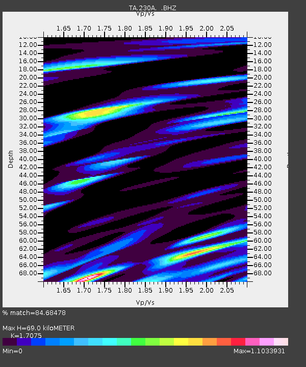
| Estimated Moho Depth: |
69.0 km |
| Estimated Crust Vp/Vs: |
1.71 |
| Assumed Crust Vp: |
6.38 km/s |
| Estimated Crust Vs: |
3.737 km/s |
| Estimated Crust Poisson's Ratio: |
0.24 |
|
| Radial Match: |
84.68478 % |
| Radial Bump: |
400 |
| Transverse Match: |
70.05856 % |
| Transverse Bump: |
400 |
| SOD ConfigId: |
2622 |
| Insert Time: |
2010-03-05 23:40:57.037 +0000 |
| GWidth: |
2.5 |
| Max Bumps: |
400 |
| Tol: |
0.001 |
|

Signal To Noise
| Channel | StoN | STA | LTA |
| TA:230A: :BHZ:20090929T23:56:58.425027Z | 4.720127 | 8.1915096E-7 | 1.7354425E-7 |
| TA:230A: :BHN:20090929T23:56:58.425027Z | 0.95314085 | 9.173044E-8 | 9.624017E-8 |
| TA:230A: :BHE:20090929T23:56:58.425027Z | 1.6934506 | 2.2592837E-7 | 1.3341304E-7 |
| Arrivals |
| Ps | 7.9 SECOND |
| PpPs | 29 SECOND |
| PsPs/PpSs | 36 SECOND |


