You are here: Home > Network List > TA - USArray Transportable Network (new EarthScope stations) Stations List
> Station 230A Sterling City, TX, USA > Earthquake Result Viewer
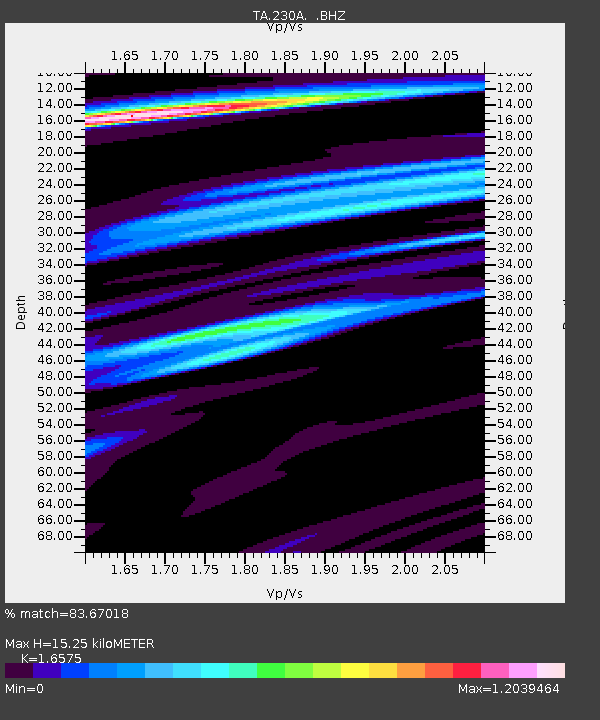
230A Sterling City, TX, USA - Earthquake Result Viewer
| Earthquake location: |
Off Coast Of Ecuador |
| Earthquake latitude/longitude: |
1.4/-85.2 |
| Earthquake time(UTC): |
2009/05/10 (130) 01:16:06 GMT |
| Earthquake Depth: |
6.0 km |
| Earthquake Magnitude: |
5.5 MB, 5.7 MS, 6.1 MW, 6.1 MW |
| Earthquake Catalog/Contributor: |
WHDF/NEIC |
|
| Network: |
TA USArray Transportable Network (new EarthScope stations) |
| Station: |
230A Sterling City, TX, USA |
| Lat/Lon: |
31.89 N/101.11 W |
| Elevation: |
742 m |
|
| Distance: |
33.9 deg |
| Az: |
335.204 deg |
| Baz: |
150.471 deg |
| Ray Param: |
0.07802174 |
| Estimated Moho Depth: |
15.25 km |
| Estimated Crust Vp/Vs: |
1.66 |
| Assumed Crust Vp: |
6.38 km/s |
| Estimated Crust Vs: |
3.849 km/s |
| Estimated Crust Poisson's Ratio: |
0.21 |
|
| Radial Match: |
83.67018 % |
| Radial Bump: |
373 |
| Transverse Match: |
69.31784 % |
| Transverse Bump: |
400 |
| SOD ConfigId: |
2760 |
| Insert Time: |
2010-03-05 23:41:15.514 +0000 |
| GWidth: |
2.5 |
| Max Bumps: |
400 |
| Tol: |
0.001 |
|

Signal To Noise
| Channel | StoN | STA | LTA |
| TA:230A: :BHZ:20090510T01:22:19.423989Z | 7.0639806 | 7.208008E-7 | 1.02038896E-7 |
| TA:230A: :BHN:20090510T01:22:19.423989Z | 5.0578246 | 3.4643074E-7 | 6.849402E-8 |
| TA:230A: :BHE:20090510T01:22:19.423989Z | 1.6574565 | 1.9029126E-7 | 1.14809204E-7 |
| Arrivals |
| Ps | 1.7 SECOND |
| PpPs | 5.9 SECOND |
| PsPs/PpSs | 7.6 SECOND |


