You are here: Home > Network List > IU - Global Seismograph Network (GSN - IRIS/USGS) Stations List
> Station CTAO Charters Towers, Australia > Earthquake Result Viewer
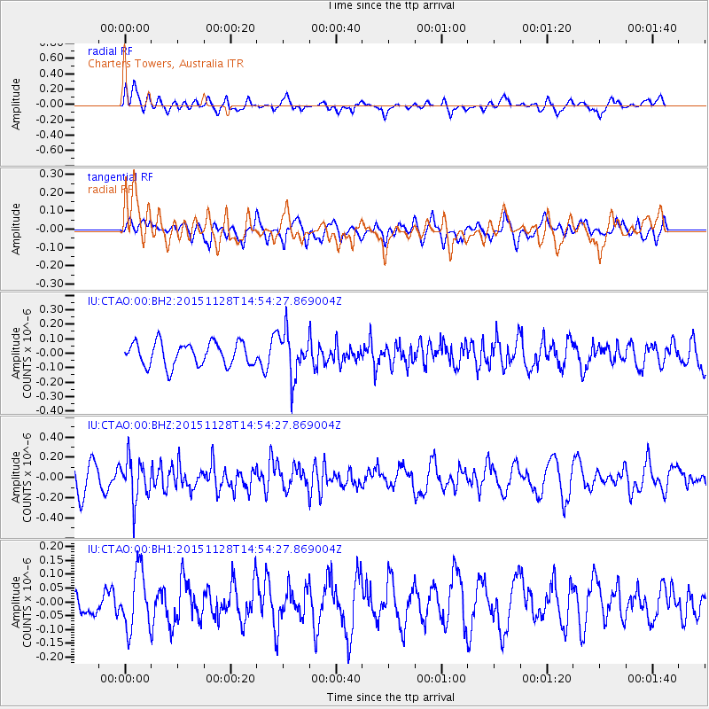
CTAO Charters Towers, Australia - Earthquake Result Viewer
*The percent match for this event was below the threshold and hence no stack was calculated.
| Earthquake location: |
Sunda Strait, Indonesia |
| Earthquake latitude/longitude: |
-7.0/106.0 |
| Earthquake time(UTC): |
2015/11/28 (332) 14:47:20 GMT |
| Earthquake Depth: |
68 km |
| Earthquake Magnitude: |
5.4 MB, 5.5 MB |
| Earthquake Catalog/Contributor: |
NEIC PDE/NEIC COMCAT |
|
| Network: |
IU Global Seismograph Network (GSN - IRIS/USGS) |
| Station: |
CTAO Charters Towers, Australia |
| Lat/Lon: |
20.09 S/146.25 E |
| Elevation: |
357 m |
|
| Distance: |
41.2 deg |
| Az: |
112.558 deg |
| Baz: |
282.744 deg |
| Ray Param: |
$rayparam |
*The percent match for this event was below the threshold and hence was not used in the summary stack. |
|
| Radial Match: |
52.816643 % |
| Radial Bump: |
400 |
| Transverse Match: |
37.575203 % |
| Transverse Bump: |
400 |
| SOD ConfigId: |
1259291 |
| Insert Time: |
2015-12-12 15:13:37.322 +0000 |
| GWidth: |
2.5 |
| Max Bumps: |
400 |
| Tol: |
0.001 |
|
Signal To Noise
| Channel | StoN | STA | LTA |
| IU:CTAO:00:BHZ:20151128T14:54:27.869004Z | 1.6055737 | 2.0609234E-7 | 1.2836057E-7 |
| IU:CTAO:00:BH1:20151128T14:54:27.869004Z | 1.5465858 | 1.058496E-7 | 6.8440826E-8 |
| IU:CTAO:00:BH2:20151128T14:54:27.869004Z | 1.9170732 | 1.5299614E-7 | 7.980714E-8 |
| Arrivals |
| Ps | |
| PpPs | |
| PsPs/PpSs | |


