You are here: Home > Network List > US - United States National Seismic Network Stations List
> Station AMTX Amarillo, Texas, USA > Earthquake Result Viewer
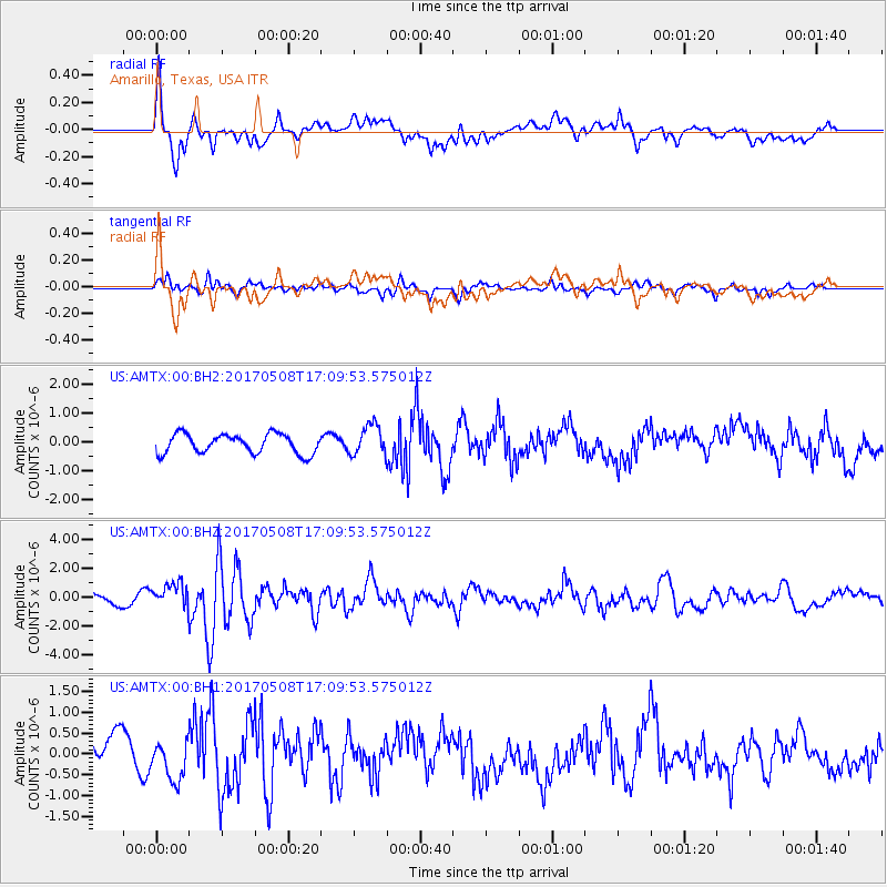
AMTX Amarillo, Texas, USA - Earthquake Result Viewer
*The percent match for this event was below the threshold and hence no stack was calculated.
| Earthquake location: |
Andreanof Islands, Aleutian Is. |
| Earthquake latitude/longitude: |
51.4/-178.6 |
| Earthquake time(UTC): |
2017/05/08 (128) 17:00:42 GMT |
| Earthquake Depth: |
1.0 km |
| Earthquake Magnitude: |
6.6 Mi |
| Earthquake Catalog/Contributor: |
NEIC PDE/at |
|
| Network: |
US United States National Seismic Network |
| Station: |
AMTX Amarillo, Texas, USA |
| Lat/Lon: |
34.53 N/101.41 W |
| Elevation: |
1010 m |
|
| Distance: |
56.3 deg |
| Az: |
75.308 deg |
| Baz: |
312.716 deg |
| Ray Param: |
$rayparam |
*The percent match for this event was below the threshold and hence was not used in the summary stack. |
|
| Radial Match: |
68.19295 % |
| Radial Bump: |
400 |
| Transverse Match: |
62.15376 % |
| Transverse Bump: |
400 |
| SOD ConfigId: |
11737051 |
| Insert Time: |
2019-04-27 07:44:36.867 +0000 |
| GWidth: |
2.5 |
| Max Bumps: |
400 |
| Tol: |
0.001 |
|
Signal To Noise
| Channel | StoN | STA | LTA |
| US:AMTX:00:BHZ:20170508T17:09:53.575012Z | 2.5976663 | 8.656022E-7 | 3.3322303E-7 |
| US:AMTX:00:BH1:20170508T17:09:53.575012Z | 1.1552138 | 4.423671E-7 | 3.8293095E-7 |
| US:AMTX:00:BH2:20170508T17:09:53.575012Z | 1.5311986 | 5.1383756E-7 | 3.3557862E-7 |
| Arrivals |
| Ps | |
| PpPs | |
| PsPs/PpSs | |


