You are here: Home > Network List > UW - Pacific Northwest Regional Seismic Network Stations List
> Station LEBA Lebam, WA, USA > Earthquake Result Viewer
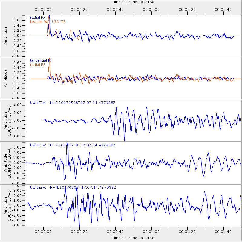
LEBA Lebam, WA, USA - Earthquake Result Viewer
*The percent match for this event was below the threshold and hence no stack was calculated.
| Earthquake location: |
Andreanof Islands, Aleutian Is. |
| Earthquake latitude/longitude: |
51.4/-178.6 |
| Earthquake time(UTC): |
2017/05/08 (128) 17:00:42 GMT |
| Earthquake Depth: |
1.0 km |
| Earthquake Magnitude: |
6.6 Mi |
| Earthquake Catalog/Contributor: |
NEIC PDE/at |
|
| Network: |
UW Pacific Northwest Regional Seismic Network |
| Station: |
LEBA Lebam, WA, USA |
| Lat/Lon: |
46.55 N/123.56 W |
| Elevation: |
73 m |
|
| Distance: |
35.7 deg |
| Az: |
75.567 deg |
| Baz: |
298.371 deg |
| Ray Param: |
$rayparam |
*The percent match for this event was below the threshold and hence was not used in the summary stack. |
|
| Radial Match: |
81.58403 % |
| Radial Bump: |
400 |
| Transverse Match: |
62.466114 % |
| Transverse Bump: |
400 |
| SOD ConfigId: |
11737051 |
| Insert Time: |
2019-04-27 07:45:13.501 +0000 |
| GWidth: |
2.5 |
| Max Bumps: |
400 |
| Tol: |
0.001 |
|
Signal To Noise
| Channel | StoN | STA | LTA |
| UW:LEBA: :HHZ:20170508T17:07:14.437988Z | 1.4209617 | 3.363247E-7 | 2.3668807E-7 |
| UW:LEBA: :HHN:20170508T17:07:14.437988Z | 0.54115975 | 2.2029879E-7 | 4.0708642E-7 |
| UW:LEBA: :HHE:20170508T17:07:14.437988Z | 1.6163826 | 4.0105542E-7 | 2.481191E-7 |
| Arrivals |
| Ps | |
| PpPs | |
| PsPs/PpSs | |


