You are here: Home > Network List > UW - Pacific Northwest Regional Seismic Network Stations List
> Station UMAT Pilot Rock, OR, USA > Earthquake Result Viewer
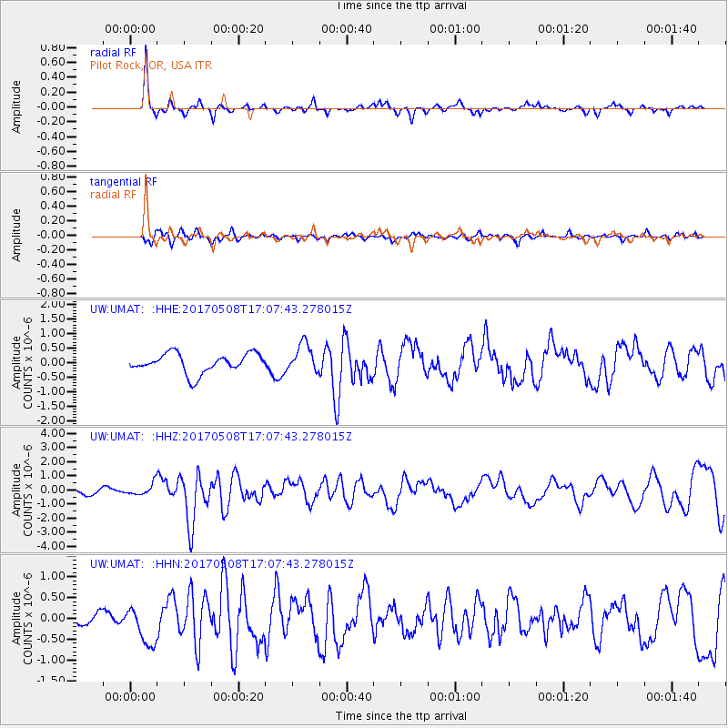
UMAT Pilot Rock, OR, USA - Earthquake Result Viewer
*The percent match for this event was below the threshold and hence no stack was calculated.
| Earthquake location: |
Andreanof Islands, Aleutian Is. |
| Earthquake latitude/longitude: |
51.4/-178.6 |
| Earthquake time(UTC): |
2017/05/08 (128) 17:00:42 GMT |
| Earthquake Depth: |
1.0 km |
| Earthquake Magnitude: |
6.6 Mi |
| Earthquake Catalog/Contributor: |
NEIC PDE/at |
|
| Network: |
UW Pacific Northwest Regional Seismic Network |
| Station: |
UMAT Pilot Rock, OR, USA |
| Lat/Lon: |
45.29 N/118.96 W |
| Elevation: |
1318 m |
|
| Distance: |
39.1 deg |
| Az: |
74.742 deg |
| Baz: |
301.013 deg |
| Ray Param: |
$rayparam |
*The percent match for this event was below the threshold and hence was not used in the summary stack. |
|
| Radial Match: |
77.508 % |
| Radial Bump: |
233 |
| Transverse Match: |
62.206856 % |
| Transverse Bump: |
400 |
| SOD ConfigId: |
11737051 |
| Insert Time: |
2019-04-27 07:45:20.265 +0000 |
| GWidth: |
2.5 |
| Max Bumps: |
400 |
| Tol: |
0.001 |
|
Signal To Noise
| Channel | StoN | STA | LTA |
| UW:UMAT: :HHZ:20170508T17:07:43.278015Z | 1.3416147 | 4.2926942E-7 | 3.1996476E-7 |
| UW:UMAT: :HHN:20170508T17:07:43.278015Z | 1.7538263 | 4.59915E-7 | 2.622352E-7 |
| UW:UMAT: :HHE:20170508T17:07:43.278015Z | 1.3144647 | 4.290639E-7 | 3.2641722E-7 |
| Arrivals |
| Ps | |
| PpPs | |
| PsPs/PpSs | |


