You are here: Home > Network List > TA - USArray Transportable Network (new EarthScope stations) Stations List
> Station 631A Perdido Creek Ranch, Del Rio, TX, USA > Earthquake Result Viewer
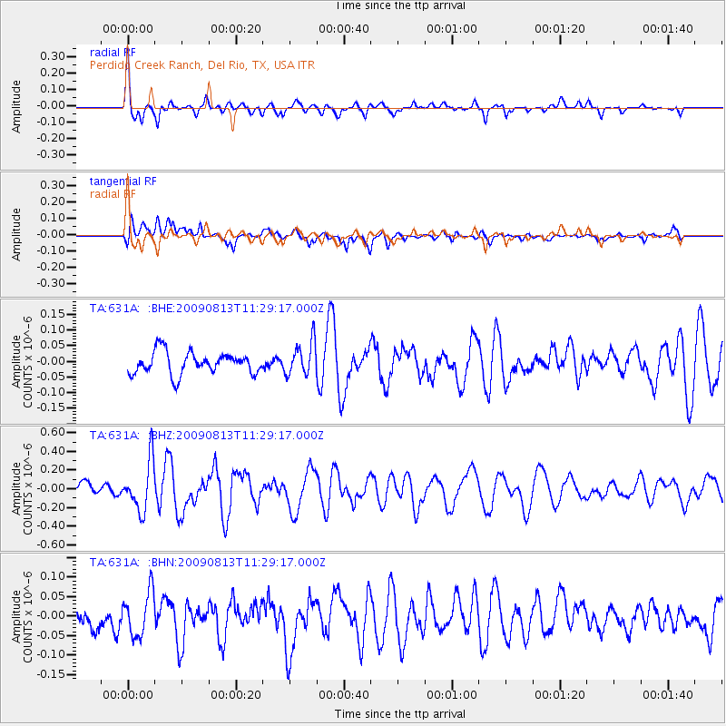
631A Perdido Creek Ranch, Del Rio, TX, USA - Earthquake Result Viewer
| Earthquake location: |
Tonga Islands |
| Earthquake latitude/longitude: |
-21.7/-174.6 |
| Earthquake time(UTC): |
2009/08/13 (225) 11:17:01 GMT |
| Earthquake Depth: |
10 km |
| Earthquake Magnitude: |
5.6 MW, 5.3 MB |
| Earthquake Catalog/Contributor: |
WHDF/NEIC |
|
| Network: |
TA USArray Transportable Network (new EarthScope stations) |
| Station: |
631A Perdido Creek Ranch, Del Rio, TX, USA |
| Lat/Lon: |
29.41 N/100.58 W |
| Elevation: |
344 m |
|
| Distance: |
87.4 deg |
| Az: |
57.088 deg |
| Baz: |
243.512 deg |
| Ray Param: |
0.04331964 |
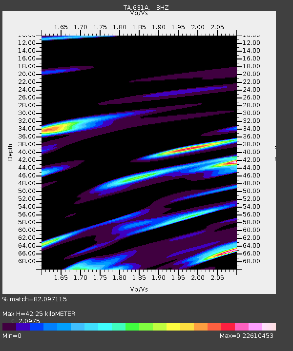
| Estimated Moho Depth: |
42.25 km |
| Estimated Crust Vp/Vs: |
2.10 |
| Assumed Crust Vp: |
6.12 km/s |
| Estimated Crust Vs: |
2.918 km/s |
| Estimated Crust Poisson's Ratio: |
0.35 |
|
| Radial Match: |
82.097115 % |
| Radial Bump: |
335 |
| Transverse Match: |
71.97066 % |
| Transverse Bump: |
400 |
| SOD ConfigId: |
2622 |
| Insert Time: |
2010-03-05 23:41:59.126 +0000 |
| GWidth: |
2.5 |
| Max Bumps: |
400 |
| Tol: |
0.001 |
|
Signal To Noise
| Channel | StoN | STA | LTA |
| TA:631A: :BHZ:20090813T11:29:17.000Z | 3.7770476 | 2.6884854E-7 | 7.117955E-8 |
| TA:631A: :BHN:20090813T11:29:17.000Z | 1.5002319 | 5.7066135E-8 | 3.803821E-8 |
| TA:631A: :BHE:20090813T11:29:17.000Z | 1.5424052 | 5.368999E-8 | 3.480926E-8 |
| Arrivals |
| Ps | 7.7 SECOND |
| PpPs | 21 SECOND |
| PsPs/PpSs | 29 SECOND |


