You are here: Home > Network List > TA - USArray Transportable Network (new EarthScope stations) Stations List
> Station 631A Perdido Creek Ranch, Del Rio, TX, USA > Earthquake Result Viewer
631A Perdido Creek Ranch, Del Rio, TX, USA - Earthquake Result Viewer
| Earthquake location: |
Samoa Islands Region |
| Earthquake latitude/longitude: |
-14.9/-174.8 |
| Earthquake time(UTC): |
2009/10/14 (287) 18:00:21 GMT |
| Earthquake Depth: |
10 km |
| Earthquake Magnitude: |
5.7 MB, 6.0 MS, 6.3 MW, 6.2 MW |
| Earthquake Catalog/Contributor: |
WHDF/NEIC |
|
| Network: |
TA USArray Transportable Network (new EarthScope stations) |
| Station: |
631A Perdido Creek Ranch, Del Rio, TX, USA |
| Lat/Lon: |
29.41 N/100.58 W |
| Elevation: |
344 m |
|
| Distance: |
84.0 deg |
| Az: |
57.6 deg |
| Baz: |
249.314 deg |
| Ray Param: |
0.045769818 |
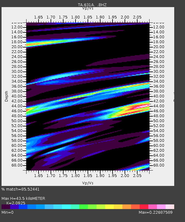
| Estimated Moho Depth: |
43.5 km |
| Estimated Crust Vp/Vs: |
2.09 |
| Assumed Crust Vp: |
6.12 km/s |
| Estimated Crust Vs: |
2.925 km/s |
| Estimated Crust Poisson's Ratio: |
0.35 |
|
| Radial Match: |
85.52441 % |
| Radial Bump: |
316 |
| Transverse Match: |
48.337807 % |
| Transverse Bump: |
377 |
| SOD ConfigId: |
2622 |
| Insert Time: |
2010-03-05 23:42:26.342 +0000 |
| GWidth: |
2.5 |
| Max Bumps: |
400 |
| Tol: |
0.001 |
|
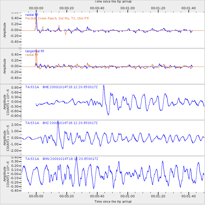
Signal To Noise
| Channel | StoN | STA | LTA |
| TA:631A: :BHZ:20091014T18:12:20.850017Z | 2.0054245 | 2.7917028E-7 | 1.3920757E-7 |
| TA:631A: :BHN:20091014T18:12:20.850017Z | 1.4977325 | 1.6262128E-7 | 1.0857831E-7 |
| TA:631A: :BHE:20091014T18:12:20.850017Z | 0.68283606 | 6.578457E-8 | 9.634021E-8 |
| Arrivals |
| Ps | 7.9 SECOND |
| PpPs | 22 SECOND |
| PsPs/PpSs | 29 SECOND |


