You are here: Home > Network List > TA - USArray Transportable Network (new EarthScope stations) Stations List
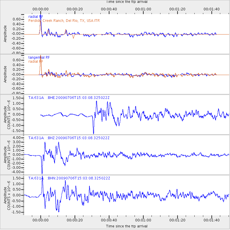
> Station 631A Perdido Creek Ranch, Del Rio, TX, USA > Earthquake Result Viewer
631A Perdido Creek Ranch, Del Rio, TX, USA - Earthquake Result Viewer
| Earthquake location: |
Rat Islands, Aleutian Islands |
| Earthquake latitude/longitude: |
50.4/177.0 |
| Earthquake time(UTC): |
2009/07/06 (187) 14:53:12 GMT |
| Earthquake Depth: |
22 km |
| Earthquake Magnitude: |
6.0 MB, 5.8 MS, 6.1 MW, 6.0 MW |
| Earthquake Catalog/Contributor: |
WHDF/NEIC |
|
| Network: |
TA USArray Transportable Network (new EarthScope stations) |
| Station: |
631A Perdido Creek Ranch, Del Rio, TX, USA |
| Lat/Lon: |
29.41 N/100.58 W |
| Elevation: |
344 m |
|
| Distance: |
63.3 deg |
| Az: |
75.474 deg |
| Baz: |
314.806 deg |
| Ray Param: |
0.05963122 |
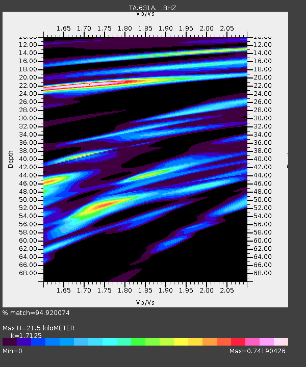
| Estimated Moho Depth: |
21.5 km |
| Estimated Crust Vp/Vs: |
1.71 |
| Assumed Crust Vp: |
6.12 km/s |
| Estimated Crust Vs: |
3.574 km/s |
| Estimated Crust Poisson's Ratio: |
0.24 |
|
| Radial Match: |
94.920074 % |
| Radial Bump: |
400 |
| Transverse Match: |
79.79375 % |
| Transverse Bump: |
400 |
| SOD ConfigId: |
2648 |
| Insert Time: |
2010-03-05 23:42:36.292 +0000 |
| GWidth: |
2.5 |
| Max Bumps: |
400 |
| Tol: |
0.001 |
|
Signal To Noise
| Channel | StoN | STA | LTA |
| TA:631A: :BHZ:20090706T15:03:08.325022Z | 11.627996 | 1.5213221E-6 | 1.3083269E-7 |
| TA:631A: :BHN:20090706T15:03:08.325022Z | 6.179219 | 5.976375E-7 | 9.671732E-8 |
| TA:631A: :BHE:20090706T15:03:08.325022Z | 7.4960732 | 6.337658E-7 | 8.454637E-8 |
| Arrivals |
| Ps | 2.6 SECOND |
| PpPs | 9.1 SECOND |
| PsPs/PpSs | 12 SECOND |


