You are here: Home > Network List > MN - MEDNET Project Stations List
> Station VTS Vitosha, Bulgary > Earthquake Result Viewer
VTS Vitosha, Bulgary - Earthquake Result Viewer
| Earthquake location: |
Ryukyu Islands, Japan |
| Earthquake latitude/longitude: |
24.4/126.3 |
| Earthquake time(UTC): |
2017/05/09 (129) 01:54:14 GMT |
| Earthquake Depth: |
10 km |
| Earthquake Magnitude: |
6.0 Mww |
| Earthquake Catalog/Contributor: |
NEIC PDE/us |
|
| Network: |
MN MEDNET Project |
| Station: |
VTS Vitosha, Bulgary |
| Lat/Lon: |
42.62 N/23.24 E |
| Elevation: |
1490 m |
|
| Distance: |
82.8 deg |
| Az: |
313.546 deg |
| Baz: |
63.505 deg |
| Ray Param: |
0.04664852 |
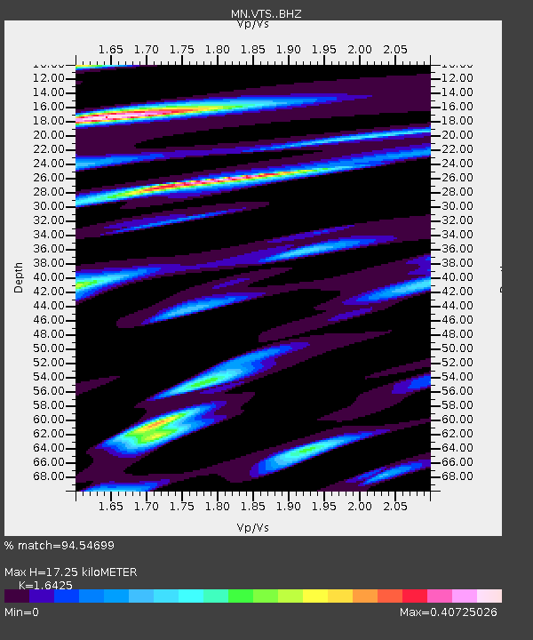
| Estimated Moho Depth: |
17.25 km |
| Estimated Crust Vp/Vs: |
1.64 |
| Assumed Crust Vp: |
6.291 km/s |
| Estimated Crust Vs: |
3.83 km/s |
| Estimated Crust Poisson's Ratio: |
0.21 |
|
| Radial Match: |
94.54699 % |
| Radial Bump: |
400 |
| Transverse Match: |
87.36811 % |
| Transverse Bump: |
400 |
| SOD ConfigId: |
11737051 |
| Insert Time: |
2019-04-27 07:51:11.791 +0000 |
| GWidth: |
2.5 |
| Max Bumps: |
400 |
| Tol: |
0.001 |
|

Signal To Noise
| Channel | StoN | STA | LTA |
| MN:VTS: :BHZ:20170509T02:06:07.32603Z | 6.5053806 | 2.9501692E-7 | 4.534968E-8 |
| MN:VTS: :BHN:20170509T02:06:07.32603Z | 1.6992681 | 4.1197918E-8 | 2.4244507E-8 |
| MN:VTS: :BHE:20170509T02:06:07.32603Z | 1.7764533 | 6.698169E-8 | 3.770529E-8 |
| Arrivals |
| Ps | 1.8 SECOND |
| PpPs | 7.1 SECOND |
| PsPs/PpSs | 8.9 SECOND |


