You are here: Home > Network List > TA - USArray Transportable Network (new EarthScope stations) Stations List
> Station D23K Nanushuk River, AK USA > Earthquake Result Viewer
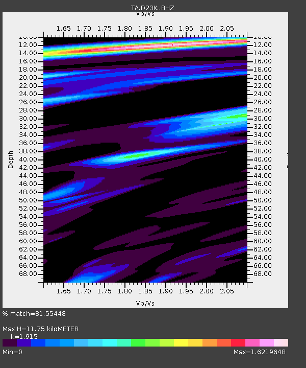
D23K Nanushuk River, AK USA - Earthquake Result Viewer
| Earthquake location: |
Ryukyu Islands, Japan |
| Earthquake latitude/longitude: |
24.4/126.3 |
| Earthquake time(UTC): |
2017/05/09 (129) 01:54:14 GMT |
| Earthquake Depth: |
10 km |
| Earthquake Magnitude: |
6.0 Mww |
| Earthquake Catalog/Contributor: |
NEIC PDE/us |
|
| Network: |
TA USArray Transportable Network (new EarthScope stations) |
| Station: |
D23K Nanushuk River, AK USA |
| Lat/Lon: |
68.97 N/150.68 W |
| Elevation: |
406 m |
|
| Distance: |
64.9 deg |
| Az: |
23.305 deg |
| Baz: |
272.875 deg |
| Ray Param: |
0.058601607 |
| Estimated Moho Depth: |
11.75 km |
| Estimated Crust Vp/Vs: |
1.91 |
| Assumed Crust Vp: |
6.221 km/s |
| Estimated Crust Vs: |
3.249 km/s |
| Estimated Crust Poisson's Ratio: |
0.31 |
|
| Radial Match: |
81.55448 % |
| Radial Bump: |
400 |
| Transverse Match: |
68.74381 % |
| Transverse Bump: |
400 |
| SOD ConfigId: |
11737051 |
| Insert Time: |
2019-04-27 07:52:24.103 +0000 |
| GWidth: |
2.5 |
| Max Bumps: |
400 |
| Tol: |
0.001 |
|

Signal To Noise
| Channel | StoN | STA | LTA |
| TA:D23K: :BHZ:20170509T02:04:22.900005Z | 2.5867863 | 4.0216614E-7 | 1.5546941E-7 |
| TA:D23K: :BHN:20170509T02:04:22.900005Z | 0.7811175 | 7.2674844E-8 | 9.303958E-8 |
| TA:D23K: :BHE:20170509T02:04:22.900005Z | 0.9642668 | 1.3100792E-7 | 1.3586273E-7 |
| Arrivals |
| Ps | 1.8 SECOND |
| PpPs | 5.3 SECOND |
| PsPs/PpSs | 7.1 SECOND |


