You are here: Home > Network List > TA - USArray Transportable Network (new EarthScope stations) Stations List
> Station P17K Kvichak River, AK, USA > Earthquake Result Viewer
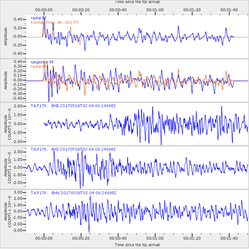
P17K Kvichak River, AK, USA - Earthquake Result Viewer
*The percent match for this event was below the threshold and hence no stack was calculated.
| Earthquake location: |
Ryukyu Islands, Japan |
| Earthquake latitude/longitude: |
24.4/126.3 |
| Earthquake time(UTC): |
2017/05/09 (129) 01:54:14 GMT |
| Earthquake Depth: |
10 km |
| Earthquake Magnitude: |
6.0 Mww |
| Earthquake Catalog/Contributor: |
NEIC PDE/us |
|
| Network: |
TA USArray Transportable Network (new EarthScope stations) |
| Station: |
P17K Kvichak River, AK, USA |
| Lat/Lon: |
59.20 N/156.44 W |
| Elevation: |
91 m |
|
| Distance: |
62.9 deg |
| Az: |
34.34 deg |
| Baz: |
272.551 deg |
| Ray Param: |
$rayparam |
*The percent match for this event was below the threshold and hence was not used in the summary stack. |
|
| Radial Match: |
69.86477 % |
| Radial Bump: |
400 |
| Transverse Match: |
65.70296 % |
| Transverse Bump: |
400 |
| SOD ConfigId: |
11737051 |
| Insert Time: |
2019-04-27 07:52:44.038 +0000 |
| GWidth: |
2.5 |
| Max Bumps: |
400 |
| Tol: |
0.001 |
|
Signal To Noise
| Channel | StoN | STA | LTA |
| TA:P17K: :BHZ:20170509T02:04:09.24998Z | 1.9344037 | 4.3158883E-7 | 2.2311208E-7 |
| TA:P17K: :BHN:20170509T02:04:09.24998Z | 1.4928938 | 7.2777414E-7 | 4.874923E-7 |
| TA:P17K: :BHE:20170509T02:04:09.24998Z | 1.2794971 | 3.210391E-7 | 2.5091038E-7 |
| Arrivals |
| Ps | |
| PpPs | |
| PsPs/PpSs | |


