You are here: Home > Network List > AV - Alaska Volcano Observatory Stations List
> Station MAPS Pakushin Southeast, Makushin Volcano, Alaska > Earthquake Result Viewer
MAPS Pakushin Southeast, Makushin Volcano, Alaska - Earthquake Result Viewer

| Earthquake location: |
Vanuatu Islands |
| Earthquake latitude/longitude: |
-14.6/167.4 |
| Earthquake time(UTC): |
2017/05/09 (129) 13:52:10 GMT |
| Earthquake Depth: |
169 km |
| Earthquake Magnitude: |
6.8 mww |
| Earthquake Catalog/Contributor: |
NEIC PDE/us |
|
| Network: |
AV Alaska Volcano Observatory |
| Station: |
MAPS Pakushin Southeast, Makushin Volcano, Alaska |
| Lat/Lon: |
53.81 N/166.94 W |
| Elevation: |
333 m |
|
| Distance: |
71.6 deg |
| Az: |
15.718 deg |
| Baz: |
206.246 deg |
| Ray Param: |
0.053769693 |
| Estimated Moho Depth: |
25.5 km |
| Estimated Crust Vp/Vs: |
1.69 |
| Assumed Crust Vp: |
3.943 km/s |
| Estimated Crust Vs: |
2.337 km/s |
| Estimated Crust Poisson's Ratio: |
0.23 |
|
| Radial Match: |
87.26268 % |
| Radial Bump: |
400 |
| Transverse Match: |
84.23708 % |
| Transverse Bump: |
400 |
| SOD ConfigId: |
11737051 |
| Insert Time: |
2019-04-27 07:56:57.341 +0000 |
| GWidth: |
2.5 |
| Max Bumps: |
400 |
| Tol: |
0.001 |
|
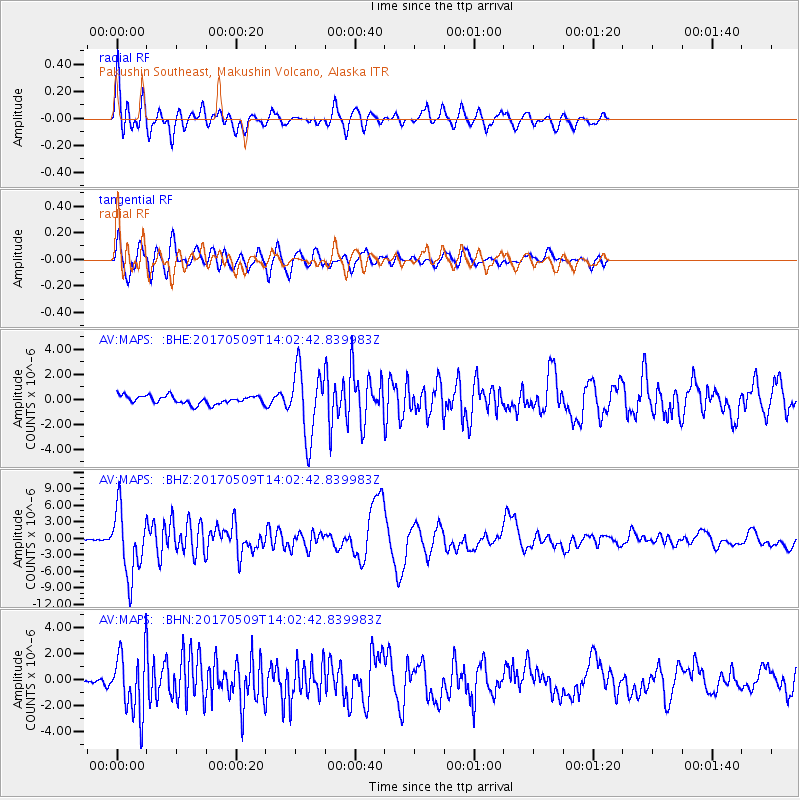
Signal To Noise
| Channel | StoN | STA | LTA |
| AV:MAPS: :BHZ:20170509T14:02:42.839983Z | 22.734354 | 5.9015883E-6 | 2.59589E-7 |
| AV:MAPS: :BHN:20170509T14:02:42.839983Z | 6.870457 | 2.33592E-6 | 3.3999484E-7 |
| AV:MAPS: :BHE:20170509T14:02:42.839983Z | 8.239873 | 2.698806E-6 | 3.2753002E-7 |
| Arrivals |
| Ps | 4.5 SECOND |
| PpPs | 17 SECOND |
| PsPs/PpSs | 22 SECOND |


