You are here: Home > Network List > TA - USArray Transportable Network (new EarthScope stations) Stations List
> Station 632A Uvalde, TX, USA > Earthquake Result Viewer
632A Uvalde, TX, USA - Earthquake Result Viewer
| Earthquake location: |
Tonga Islands |
| Earthquake latitude/longitude: |
-20.8/-174.3 |
| Earthquake time(UTC): |
2009/07/30 (211) 20:05:34 GMT |
| Earthquake Depth: |
10 km |
| Earthquake Magnitude: |
5.9 MB, 5.7 MS, 5.8 MW, 5.7 MW |
| Earthquake Catalog/Contributor: |
WHDF/NEIC |
|
| Network: |
TA USArray Transportable Network (new EarthScope stations) |
| Station: |
632A Uvalde, TX, USA |
| Lat/Lon: |
29.51 N/99.79 W |
| Elevation: |
420 m |
|
| Distance: |
87.4 deg |
| Az: |
57.216 deg |
| Baz: |
244.431 deg |
| Ray Param: |
0.043336187 |
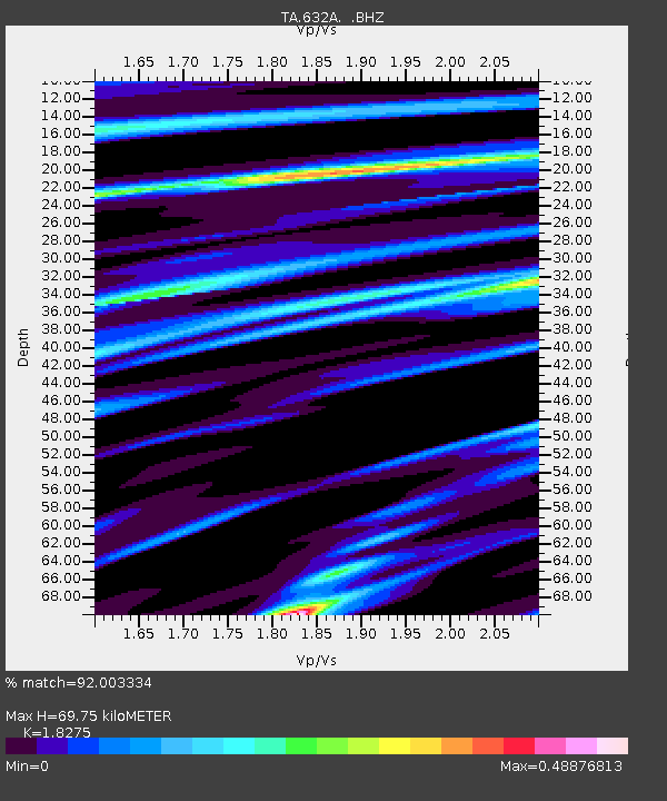
| Estimated Moho Depth: |
69.75 km |
| Estimated Crust Vp/Vs: |
1.83 |
| Assumed Crust Vp: |
6.347 km/s |
| Estimated Crust Vs: |
3.473 km/s |
| Estimated Crust Poisson's Ratio: |
0.29 |
|
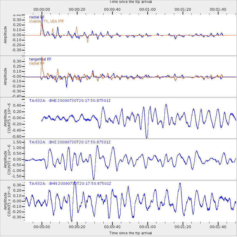
| Radial Match: |
92.003334 % |
| Radial Bump: |
225 |
| Transverse Match: |
81.86258 % |
| Transverse Bump: |
324 |
| SOD ConfigId: |
2622 |
| Insert Time: |
2010-03-05 23:43:16.041 +0000 |
| GWidth: |
2.5 |
| Max Bumps: |
400 |
| Tol: |
0.001 |
|
Signal To Noise
| Channel | StoN | STA | LTA |
| TA:632A: :BHZ:20090730T20:17:50.87501Z | 6.936962 | 4.8682915E-7 | 7.017901E-8 |
| TA:632A: :BHN:20090730T20:17:50.87501Z | 1.790154 | 9.624632E-8 | 5.3764268E-8 |
| TA:632A: :BHE:20090730T20:17:50.87501Z | 3.2065237 | 1.8198043E-7 | 5.6753183E-8 |
| Arrivals |
| Ps | 9.3 SECOND |
| PpPs | 30 SECOND |
| PsPs/PpSs | 40 SECOND |


