You are here: Home > Network List > GS - US Geological Survey Networks Stations List
> Station KAN11 Stewart Ranch, Harper County, KS, USA > Earthquake Result Viewer
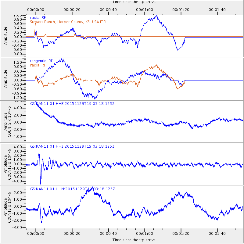
KAN11 Stewart Ranch, Harper County, KS, USA - Earthquake Result Viewer
*The percent match for this event was below the threshold and hence no stack was calculated.
| Earthquake location: |
Jujuy Province, Argentina |
| Earthquake latitude/longitude: |
-23.5/-64.6 |
| Earthquake time(UTC): |
2015/11/29 (333) 18:52:49 GMT |
| Earthquake Depth: |
9.6 km |
| Earthquake Magnitude: |
5.9 MWP |
| Earthquake Catalog/Contributor: |
NEIC PDE/NEIC COMCAT |
|
| Network: |
GS US Geological Survey Networks |
| Station: |
KAN11 Stewart Ranch, Harper County, KS, USA |
| Lat/Lon: |
37.21 N/97.91 W |
| Elevation: |
410 m |
|
| Distance: |
68.1 deg |
| Az: |
331.797 deg |
| Baz: |
147.096 deg |
| Ray Param: |
$rayparam |
*The percent match for this event was below the threshold and hence was not used in the summary stack. |
|
| Radial Match: |
27.495842 % |
| Radial Bump: |
400 |
| Transverse Match: |
34.548656 % |
| Transverse Bump: |
400 |
| SOD ConfigId: |
1259291 |
| Insert Time: |
2015-12-13 21:24:18.842 +0000 |
| GWidth: |
2.5 |
| Max Bumps: |
400 |
| Tol: |
0.001 |
|
Signal To Noise
| Channel | StoN | STA | LTA |
| GS:KAN11:01:HHZ:20151129T19:03:18.125Z | 11.156724 | 1.6920922E-6 | 1.5166567E-7 |
| GS:KAN11:01:HHN:20151129T19:03:18.125Z | 3.3718128 | 1.073939E-6 | 3.1850493E-7 |
| GS:KAN11:01:HHE:20151129T19:03:18.125Z | 1.0075178 | 1.9158772E-6 | 1.9015814E-6 |
| Arrivals |
| Ps | |
| PpPs | |
| PsPs/PpSs | |


