You are here: Home > Network List > TA - USArray Transportable Network (new EarthScope stations) Stations List
> Station 632A Uvalde, TX, USA > Earthquake Result Viewer
632A Uvalde, TX, USA - Earthquake Result Viewer
| Earthquake location: |
Peru-Bolivia Border Region |
| Earthquake latitude/longitude: |
-15.6/-69.3 |
| Earthquake time(UTC): |
2009/09/30 (273) 19:03:17 GMT |
| Earthquake Depth: |
255 km |
| Earthquake Magnitude: |
5.9 MB, 5.8 MW |
| Earthquake Catalog/Contributor: |
WHDF/NEIC |
|
| Network: |
TA USArray Transportable Network (new EarthScope stations) |
| Station: |
632A Uvalde, TX, USA |
| Lat/Lon: |
29.51 N/99.79 W |
| Elevation: |
420 m |
|
| Distance: |
53.6 deg |
| Az: |
326.663 deg |
| Baz: |
142.58 deg |
| Ray Param: |
0.065073274 |
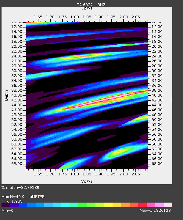
| Estimated Moho Depth: |
40.0 km |
| Estimated Crust Vp/Vs: |
1.99 |
| Assumed Crust Vp: |
6.347 km/s |
| Estimated Crust Vs: |
3.198 km/s |
| Estimated Crust Poisson's Ratio: |
0.33 |
|
| Radial Match: |
82.79239 % |
| Radial Bump: |
400 |
| Transverse Match: |
81.77534 % |
| Transverse Bump: |
400 |
| SOD ConfigId: |
2622 |
| Insert Time: |
2010-03-05 23:43:30.762 +0000 |
| GWidth: |
2.5 |
| Max Bumps: |
400 |
| Tol: |
0.001 |
|
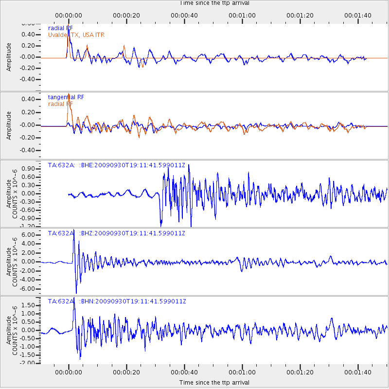
Signal To Noise
| Channel | StoN | STA | LTA |
| TA:632A: :BHZ:20090930T19:11:41.599011Z | 43.450966 | 2.8752468E-6 | 6.617222E-8 |
| TA:632A: :BHN:20090930T19:11:41.599011Z | 10.621252 | 8.0315147E-7 | 7.56174E-8 |
| TA:632A: :BHE:20090930T19:11:41.599011Z | 7.8980656 | 5.0240146E-7 | 6.36107E-8 |
| Arrivals |
| Ps | 6.5 SECOND |
| PpPs | 18 SECOND |
| PsPs/PpSs | 24 SECOND |


