You are here: Home > Network List > CI - Caltech Regional Seismic Network Stations List
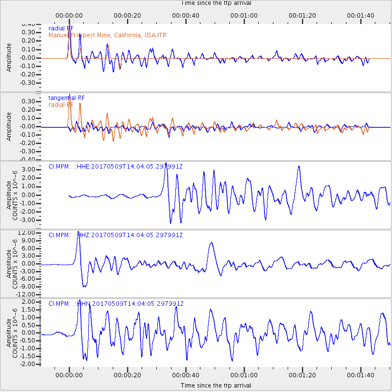
> Station MPM Manuel Prospect Mine, California, USA > Earthquake Result Viewer
MPM Manuel Prospect Mine, California, USA - Earthquake Result Viewer
| Earthquake location: |
Vanuatu Islands |
| Earthquake latitude/longitude: |
-14.6/167.4 |
| Earthquake time(UTC): |
2017/05/09 (129) 13:52:10 GMT |
| Earthquake Depth: |
169 km |
| Earthquake Magnitude: |
6.8 mww |
| Earthquake Catalog/Contributor: |
NEIC PDE/us |
|
| Network: |
CI Caltech Regional Seismic Network |
| Station: |
MPM Manuel Prospect Mine, California, USA |
| Lat/Lon: |
36.06 N/117.49 W |
| Elevation: |
185 m |
|
| Distance: |
86.9 deg |
| Az: |
51.66 deg |
| Baz: |
249.574 deg |
| Ray Param: |
0.043347217 |
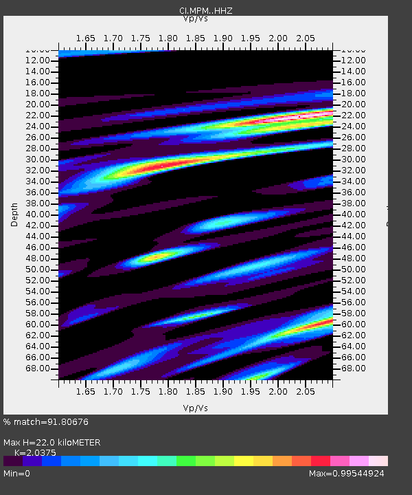
| Estimated Moho Depth: |
22.0 km |
| Estimated Crust Vp/Vs: |
2.04 |
| Assumed Crust Vp: |
6.279 km/s |
| Estimated Crust Vs: |
3.082 km/s |
| Estimated Crust Poisson's Ratio: |
0.34 |
|
| Radial Match: |
91.80676 % |
| Radial Bump: |
400 |
| Transverse Match: |
85.69833 % |
| Transverse Bump: |
400 |
| SOD ConfigId: |
11737051 |
| Insert Time: |
2019-04-27 07:58:39.360 +0000 |
| GWidth: |
2.5 |
| Max Bumps: |
400 |
| Tol: |
0.001 |
|
Signal To Noise
| Channel | StoN | STA | LTA |
| CI:MPM: :HHZ:20170509T14:04:05.297991Z | 32.876457 | 5.580897E-6 | 1.697536E-7 |
| CI:MPM: :HHN:20170509T14:04:05.297991Z | 10.635594 | 9.396394E-7 | 8.834856E-8 |
| CI:MPM: :HHE:20170509T14:04:05.297991Z | 13.410405 | 1.7630108E-6 | 1.314659E-7 |
| Arrivals |
| Ps | 3.7 SECOND |
| PpPs | 10 SECOND |
| PsPs/PpSs | 14 SECOND |


