You are here: Home > Network List > CI - Caltech Regional Seismic Network Stations List
> Station MUR Murrieta > Earthquake Result Viewer
MUR Murrieta - Earthquake Result Viewer

| Earthquake location: |
Vanuatu Islands |
| Earthquake latitude/longitude: |
-14.6/167.4 |
| Earthquake time(UTC): |
2017/05/09 (129) 13:52:10 GMT |
| Earthquake Depth: |
169 km |
| Earthquake Magnitude: |
6.8 mww |
| Earthquake Catalog/Contributor: |
NEIC PDE/us |
|
| Network: |
CI Caltech Regional Seismic Network |
| Station: |
MUR Murrieta |
| Lat/Lon: |
33.60 N/117.20 W |
| Elevation: |
562 m |
|
| Distance: |
86.3 deg |
| Az: |
54.049 deg |
| Baz: |
249.884 deg |
| Ray Param: |
0.04379513 |
| Estimated Moho Depth: |
33.0 km |
| Estimated Crust Vp/Vs: |
1.62 |
| Assumed Crust Vp: |
6.264 km/s |
| Estimated Crust Vs: |
3.872 km/s |
| Estimated Crust Poisson's Ratio: |
0.19 |
|
| Radial Match: |
93.3482 % |
| Radial Bump: |
400 |
| Transverse Match: |
80.84051 % |
| Transverse Bump: |
400 |
| SOD ConfigId: |
11737051 |
| Insert Time: |
2019-04-27 07:58:40.492 +0000 |
| GWidth: |
2.5 |
| Max Bumps: |
400 |
| Tol: |
0.001 |
|
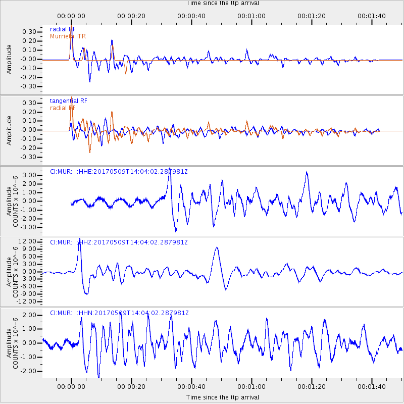
Signal To Noise
| Channel | StoN | STA | LTA |
| CI:MUR: :HHZ:20170509T14:04:02.287981Z | 28.71187 | 6.001024E-6 | 2.0900846E-7 |
| CI:MUR: :HHN:20170509T14:04:02.287981Z | 2.6100202 | 8.0894324E-7 | 3.0993755E-7 |
| CI:MUR: :HHE:20170509T14:04:02.287981Z | 6.0209928 | 1.8827348E-6 | 3.1269505E-7 |
| Arrivals |
| Ps | 3.3 SECOND |
| PpPs | 13 SECOND |
| PsPs/PpSs | 17 SECOND |


