You are here: Home > Network List > CI - Caltech Regional Seismic Network Stations List
> Station SLA SLA, Trona, CA, USA > Earthquake Result Viewer
SLA SLA, Trona, CA, USA - Earthquake Result Viewer
| Earthquake location: |
Vanuatu Islands |
| Earthquake latitude/longitude: |
-14.6/167.4 |
| Earthquake time(UTC): |
2017/05/09 (129) 13:52:10 GMT |
| Earthquake Depth: |
169 km |
| Earthquake Magnitude: |
6.8 mww |
| Earthquake Catalog/Contributor: |
NEIC PDE/us |
|
| Network: |
CI Caltech Regional Seismic Network |
| Station: |
SLA SLA, Trona, CA, USA |
| Lat/Lon: |
35.89 N/117.28 W |
| Elevation: |
1174 m |
|
| Distance: |
87.0 deg |
| Az: |
51.875 deg |
| Baz: |
249.706 deg |
| Ray Param: |
0.043278895 |
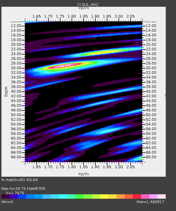
| Estimated Moho Depth: |
28.75 km |
| Estimated Crust Vp/Vs: |
1.77 |
| Assumed Crust Vp: |
6.276 km/s |
| Estimated Crust Vs: |
3.551 km/s |
| Estimated Crust Poisson's Ratio: |
0.26 |
|
| Radial Match: |
93.45164 % |
| Radial Bump: |
400 |
| Transverse Match: |
87.4619 % |
| Transverse Bump: |
400 |
| SOD ConfigId: |
11737051 |
| Insert Time: |
2019-04-27 07:58:53.144 +0000 |
| GWidth: |
2.5 |
| Max Bumps: |
400 |
| Tol: |
0.001 |
|
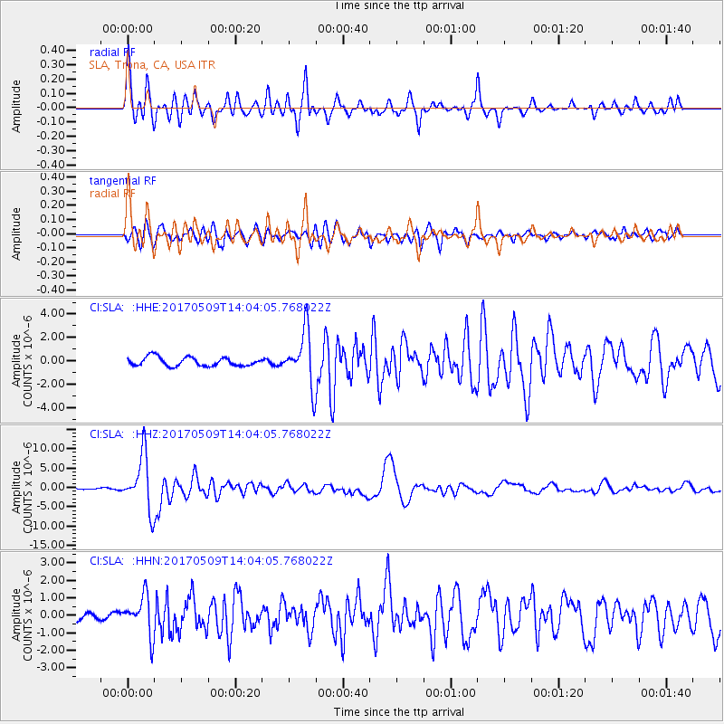
Signal To Noise
| Channel | StoN | STA | LTA |
| CI:SLA: :HHZ:20170509T14:04:05.768022Z | 41.59694 | 7.093984E-6 | 1.7054101E-7 |
| CI:SLA: :HHN:20170509T14:04:05.768022Z | 5.7824907 | 1.1249928E-6 | 1.9455159E-7 |
| CI:SLA: :HHE:20170509T14:04:05.768022Z | 6.305373 | 2.3339119E-6 | 3.701465E-7 |
| Arrivals |
| Ps | 3.6 SECOND |
| PpPs | 12 SECOND |
| PsPs/PpSs | 16 SECOND |


