You are here: Home > Network List > CN - Canadian National Seismograph Network Stations List
> Station HYT Haines Jct., YT, CA > Earthquake Result Viewer
HYT Haines Jct., YT, CA - Earthquake Result Viewer
| Earthquake location: |
Vanuatu Islands |
| Earthquake latitude/longitude: |
-14.6/167.4 |
| Earthquake time(UTC): |
2017/05/09 (129) 13:52:10 GMT |
| Earthquake Depth: |
169 km |
| Earthquake Magnitude: |
6.8 mww |
| Earthquake Catalog/Contributor: |
NEIC PDE/us |
|
| Network: |
CN Canadian National Seismograph Network |
| Station: |
HYT Haines Jct., YT, CA |
| Lat/Lon: |
60.83 N/137.51 W |
| Elevation: |
1373 m |
|
| Distance: |
87.0 deg |
| Az: |
23.734 deg |
| Baz: |
232.684 deg |
| Ray Param: |
0.043286342 |
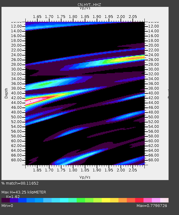
| Estimated Moho Depth: |
43.25 km |
| Estimated Crust Vp/Vs: |
1.62 |
| Assumed Crust Vp: |
6.566 km/s |
| Estimated Crust Vs: |
4.053 km/s |
| Estimated Crust Poisson's Ratio: |
0.19 |
|
| Radial Match: |
88.11652 % |
| Radial Bump: |
400 |
| Transverse Match: |
70.33311 % |
| Transverse Bump: |
400 |
| SOD ConfigId: |
11737051 |
| Insert Time: |
2019-04-27 07:59:23.829 +0000 |
| GWidth: |
2.5 |
| Max Bumps: |
400 |
| Tol: |
0.001 |
|

Signal To Noise
| Channel | StoN | STA | LTA |
| CN:HYT: :HHZ:20170509T14:04:05.709978Z | 21.096567 | 2.7587243E-6 | 1.3076651E-7 |
| CN:HYT: :HHN:20170509T14:04:05.709978Z | 4.450775 | 7.132863E-7 | 1.6026114E-7 |
| CN:HYT: :HHE:20170509T14:04:05.709978Z | 7.5126734 | 8.714049E-7 | 1.1599131E-7 |
| Arrivals |
| Ps | 4.2 SECOND |
| PpPs | 17 SECOND |
| PsPs/PpSs | 21 SECOND |


