You are here: Home > Network List > CN - Canadian National Seismograph Network Stations List
> Station PHC Port Hardy, BC, CA > Earthquake Result Viewer
PHC Port Hardy, BC, CA - Earthquake Result Viewer
| Earthquake location: |
Vanuatu Islands |
| Earthquake latitude/longitude: |
-14.6/167.4 |
| Earthquake time(UTC): |
2017/05/09 (129) 13:52:10 GMT |
| Earthquake Depth: |
169 km |
| Earthquake Magnitude: |
6.8 mww |
| Earthquake Catalog/Contributor: |
NEIC PDE/us |
|
| Network: |
CN Canadian National Seismograph Network |
| Station: |
PHC Port Hardy, BC, CA |
| Lat/Lon: |
50.71 N/127.43 W |
| Elevation: |
32 m |
|
| Distance: |
86.3 deg |
| Az: |
35.337 deg |
| Baz: |
241.721 deg |
| Ray Param: |
0.043780725 |
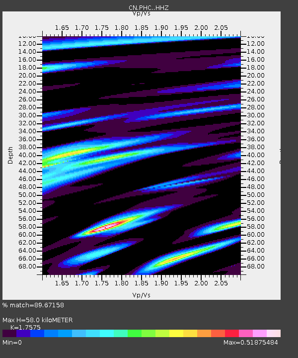
| Estimated Moho Depth: |
58.0 km |
| Estimated Crust Vp/Vs: |
1.76 |
| Assumed Crust Vp: |
6.545 km/s |
| Estimated Crust Vs: |
3.724 km/s |
| Estimated Crust Poisson's Ratio: |
0.26 |
|
| Radial Match: |
89.67158 % |
| Radial Bump: |
400 |
| Transverse Match: |
76.744316 % |
| Transverse Bump: |
400 |
| SOD ConfigId: |
11737051 |
| Insert Time: |
2019-04-27 07:59:40.204 +0000 |
| GWidth: |
2.5 |
| Max Bumps: |
400 |
| Tol: |
0.001 |
|

Signal To Noise
| Channel | StoN | STA | LTA |
| CN:PHC: :HHZ:20170509T14:04:02.370012Z | 26.327173 | 5.7711923E-6 | 2.1921048E-7 |
| CN:PHC: :HHN:20170509T14:04:02.370012Z | 4.478071 | 8.807564E-7 | 1.9668208E-7 |
| CN:PHC: :HHE:20170509T14:04:02.370012Z | 5.0876093 | 1.580045E-6 | 3.105673E-7 |
| Arrivals |
| Ps | 6.9 SECOND |
| PpPs | 24 SECOND |
| PsPs/PpSs | 31 SECOND |


