You are here: Home > Network List > TA - USArray Transportable Network (new EarthScope stations) Stations List
> Station 632A Uvalde, TX, USA > Earthquake Result Viewer
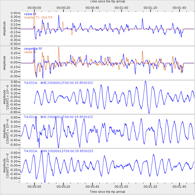
632A Uvalde, TX, USA - Earthquake Result Viewer
*The percent match for this event was below the threshold and hence no stack was calculated.
| Earthquake location: |
Kuril Islands |
| Earthquake latitude/longitude: |
48.3/154.2 |
| Earthquake time(UTC): |
2009/09/11 (254) 08:49:11 GMT |
| Earthquake Depth: |
35 km |
| Earthquake Magnitude: |
5.8 MB, 5.0 MS, 5.6 MW, 5.6 MW |
| Earthquake Catalog/Contributor: |
WHDF/NEIC |
|
| Network: |
TA USArray Transportable Network (new EarthScope stations) |
| Station: |
632A Uvalde, TX, USA |
| Lat/Lon: |
29.51 N/99.79 W |
| Elevation: |
420 m |
|
| Distance: |
78.2 deg |
| Az: |
58.88 deg |
| Baz: |
319.017 deg |
| Ray Param: |
$rayparam |
*The percent match for this event was below the threshold and hence was not used in the summary stack. |
|
| Radial Match: |
34.799164 % |
| Radial Bump: |
333 |
| Transverse Match: |
65.197876 % |
| Transverse Bump: |
400 |
| SOD ConfigId: |
2622 |
| Insert Time: |
2010-03-05 23:43:55.868 +0000 |
| GWidth: |
2.5 |
| Max Bumps: |
400 |
| Tol: |
0.001 |
|
Signal To Noise
| Channel | StoN | STA | LTA |
| TA:632A: :BHZ:20090911T09:00:36.850015Z | 1.2581517 | 3.2688055E-7 | 2.5981015E-7 |
| TA:632A: :BHN:20090911T09:00:36.850015Z | 2.2858481 | 4.2496993E-7 | 1.8591345E-7 |
| TA:632A: :BHE:20090911T09:00:36.850015Z | 1.4191613 | 2.786604E-7 | 1.9635569E-7 |
| Arrivals |
| Ps | |
| PpPs | |
| PsPs/PpSs | |


