You are here: Home > Network List > TA - USArray Transportable Network (new EarthScope stations) Stations List
> Station 632A Uvalde, TX, USA > Earthquake Result Viewer
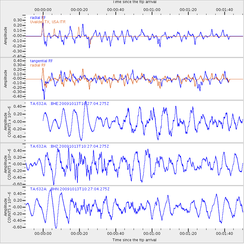
632A Uvalde, TX, USA - Earthquake Result Viewer
*The percent match for this event was below the threshold and hence no stack was calculated.
| Earthquake location: |
Kuril Islands |
| Earthquake latitude/longitude: |
44.6/149.1 |
| Earthquake time(UTC): |
2009/10/13 (286) 10:15:13 GMT |
| Earthquake Depth: |
40 km |
| Earthquake Magnitude: |
5.6 MB, 5.2 MS, 5.7 MW, 5.6 MW |
| Earthquake Catalog/Contributor: |
WHDF/NEIC |
|
| Network: |
TA USArray Transportable Network (new EarthScope stations) |
| Station: |
632A Uvalde, TX, USA |
| Lat/Lon: |
29.51 N/99.79 W |
| Elevation: |
420 m |
|
| Distance: |
83.2 deg |
| Az: |
54.998 deg |
| Baz: |
317.813 deg |
| Ray Param: |
$rayparam |
*The percent match for this event was below the threshold and hence was not used in the summary stack. |
|
| Radial Match: |
46.35452 % |
| Radial Bump: |
333 |
| Transverse Match: |
63.914337 % |
| Transverse Bump: |
368 |
| SOD ConfigId: |
2622 |
| Insert Time: |
2010-03-05 23:43:58.666 +0000 |
| GWidth: |
2.5 |
| Max Bumps: |
400 |
| Tol: |
0.001 |
|
Signal To Noise
| Channel | StoN | STA | LTA |
| TA:632A: :BHZ:20091013T10:27:04.275Z | 1.8036808 | 2.071371E-7 | 1.14841335E-7 |
| TA:632A: :BHN:20091013T10:27:04.275Z | 2.1308918 | 3.3472466E-7 | 1.5708196E-7 |
| TA:632A: :BHE:20091013T10:27:04.275Z | 0.33198518 | 8.260022E-8 | 2.4880694E-7 |
| Arrivals |
| Ps | |
| PpPs | |
| PsPs/PpSs | |


