You are here: Home > Network List > TA - USArray Transportable Network (new EarthScope stations) Stations List
> Station 632A Uvalde, TX, USA > Earthquake Result Viewer
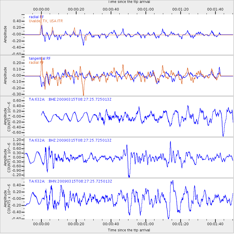
632A Uvalde, TX, USA - Earthquake Result Viewer
*The percent match for this event was below the threshold and hence no stack was calculated.
| Earthquake location: |
Central Peru |
| Earthquake latitude/longitude: |
-14.5/-70.4 |
| Earthquake time(UTC): |
2009/03/15 (074) 08:19:05 GMT |
| Earthquake Depth: |
190 km |
| Earthquake Magnitude: |
5.7 MW, 5.1 MB, 5.6 MW |
| Earthquake Catalog/Contributor: |
WHDF/NEIC |
|
| Network: |
TA USArray Transportable Network (new EarthScope stations) |
| Station: |
632A Uvalde, TX, USA |
| Lat/Lon: |
29.51 N/99.79 W |
| Elevation: |
420 m |
|
| Distance: |
52.1 deg |
| Az: |
327.144 deg |
| Baz: |
142.92 deg |
| Ray Param: |
$rayparam |
*The percent match for this event was below the threshold and hence was not used in the summary stack. |
|
| Radial Match: |
65.07793 % |
| Radial Bump: |
361 |
| Transverse Match: |
48.755142 % |
| Transverse Bump: |
394 |
| SOD ConfigId: |
2658 |
| Insert Time: |
2010-03-05 23:44:09.474 +0000 |
| GWidth: |
2.5 |
| Max Bumps: |
400 |
| Tol: |
0.001 |
|
Signal To Noise
| Channel | StoN | STA | LTA |
| TA:632A: :BHZ:20090315T08:27:25.725013Z | 2.301727 | 4.48526E-7 | 1.9486498E-7 |
| TA:632A: :BHN:20090315T08:27:25.725013Z | 0.9030026 | 1.4393122E-7 | 1.5939182E-7 |
| TA:632A: :BHE:20090315T08:27:25.725013Z | 0.7355316 | 7.878181E-8 | 1.0710866E-7 |
| Arrivals |
| Ps | |
| PpPs | |
| PsPs/PpSs | |


