You are here: Home > Network List > NN - Western Great Basin/Eastern Sierra Nevada Stations List
> Station COLR Coleman Ranch, NV portable > Earthquake Result Viewer
COLR Coleman Ranch, NV portable - Earthquake Result Viewer
| Earthquake location: |
Vanuatu Islands |
| Earthquake latitude/longitude: |
-14.6/167.4 |
| Earthquake time(UTC): |
2017/05/09 (129) 13:52:10 GMT |
| Earthquake Depth: |
169 km |
| Earthquake Magnitude: |
6.8 mww |
| Earthquake Catalog/Contributor: |
NEIC PDE/us |
|
| Network: |
NN Western Great Basin/Eastern Sierra Nevada |
| Station: |
COLR Coleman Ranch, NV portable |
| Lat/Lon: |
41.96 N/119.79 W |
| Elevation: |
1482 m |
|
| Distance: |
87.3 deg |
| Az: |
45.512 deg |
| Baz: |
247.819 deg |
| Ray Param: |
0.043007635 |
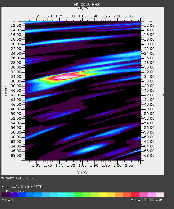
| Estimated Moho Depth: |
34.0 km |
| Estimated Crust Vp/Vs: |
1.79 |
| Assumed Crust Vp: |
6.276 km/s |
| Estimated Crust Vs: |
3.511 km/s |
| Estimated Crust Poisson's Ratio: |
0.27 |
|
| Radial Match: |
86.81611 % |
| Radial Bump: |
400 |
| Transverse Match: |
77.39265 % |
| Transverse Bump: |
400 |
| SOD ConfigId: |
11737051 |
| Insert Time: |
2019-04-27 08:02:08.716 +0000 |
| GWidth: |
2.5 |
| Max Bumps: |
400 |
| Tol: |
0.001 |
|

Signal To Noise
| Channel | StoN | STA | LTA |
| NN:COLR: :HHZ:20170509T14:04:07.539995Z | 20.473885 | 5.828752E-6 | 2.8469205E-7 |
| NN:COLR: :HHN:20170509T14:04:07.539995Z | 1.9746715 | 7.860323E-7 | 3.9805724E-7 |
| NN:COLR: :HHE:20170509T14:04:07.539995Z | 5.6294065 | 1.5436631E-6 | 2.742142E-7 |
| Arrivals |
| Ps | 4.4 SECOND |
| PpPs | 15 SECOND |
| PsPs/PpSs | 19 SECOND |


