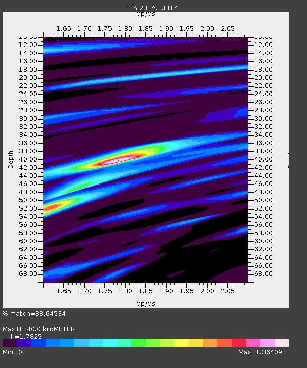
231A Bronte, TX, USA - Earthquake Result Viewer
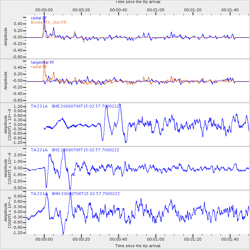
Earthquake location: Rat Islands, Aleutian Islands
Earthquake latitude/longitude: 50.4/177.0
Earthquake time(UTC): 2009/07/06 (187) 14:53:12 GMT
Earthquake Depth: 22 km
Earthquake Magnitude: 6.0 MB, 5.8 MS, 6.1 MW, 6.0 MW
Earthquake Catalog/Contributor: WHDF/NEIC
Network: TA USArray Transportable Network (new EarthScope stations)
Station: 231A Bronte, TX, USA
Lat/Lon: 31.94 N/100.32 W
Elevation: 574 m
Distance: 61.7 deg
Az: 73.271 deg
Baz: 313.92 deg
Ray Param: 0.060671367
Estimated Moho Depth: 40.0 km
Estimated Crust Vp/Vs: 1.78
Assumed Crust Vp: 6.38 km/s
Estimated Crust Vs: 3.58 km/s
Estimated Crust Poisson's Ratio: 0.27
Radial Match: 88.64534 %
Radial Bump: 400
Transverse Match: 75.0929 %
Transverse Bump: 400
SOD ConfigId: 2622
Insert Time: 2010-03-05 23:44:15.504 +0000
GWidth: 2.5
Max Bumps: 400
Tol: 0.001

Signal To Noise

ChannelStoNSTALTA
TA:231A: :BHZ:20090706T15:02:57.700022Z7.7874641.5353901E-61.9716175E-7
TA:231A: :BHN:20090706T15:02:57.700022Z2.00813415.43907E-72.7085193E-7
TA:231A: :BHE:20090706T15:02:57.700022Z4.20731267.098451E-71.68717E-7
Arrivals
Ps5.1 SECOND
PpPs17 SECOND
PsPs/PpSs22 SECOND