You are here: Home > Network List > IW - Intermountain West Stations List
> Station MOOW Moose Ponds, Wyoming, USA > Earthquake Result Viewer
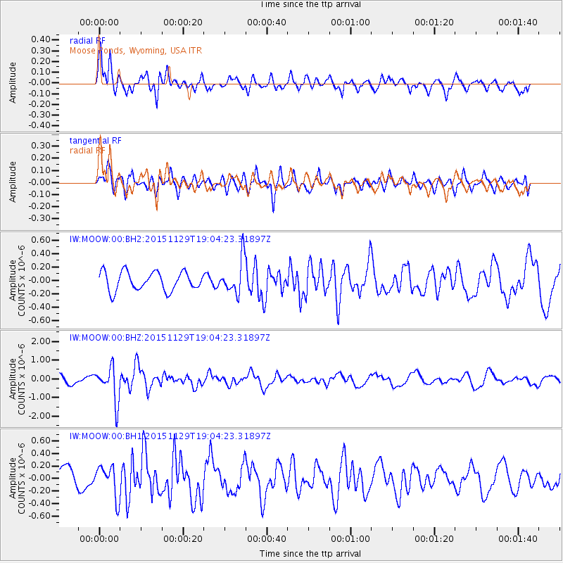
MOOW Moose Ponds, Wyoming, USA - Earthquake Result Viewer
*The percent match for this event was below the threshold and hence no stack was calculated.
| Earthquake location: |
Jujuy Province, Argentina |
| Earthquake latitude/longitude: |
-23.5/-64.6 |
| Earthquake time(UTC): |
2015/11/29 (333) 18:52:49 GMT |
| Earthquake Depth: |
9.6 km |
| Earthquake Magnitude: |
5.9 MWP |
| Earthquake Catalog/Contributor: |
NEIC PDE/NEIC COMCAT |
|
| Network: |
IW Intermountain West |
| Station: |
MOOW Moose Ponds, Wyoming, USA |
| Lat/Lon: |
43.75 N/110.74 W |
| Elevation: |
2128 m |
|
| Distance: |
79.2 deg |
| Az: |
327.864 deg |
| Baz: |
137.652 deg |
| Ray Param: |
$rayparam |
*The percent match for this event was below the threshold and hence was not used in the summary stack. |
|
| Radial Match: |
75.58856 % |
| Radial Bump: |
400 |
| Transverse Match: |
55.039867 % |
| Transverse Bump: |
400 |
| SOD ConfigId: |
1259291 |
| Insert Time: |
2015-12-13 21:26:46.314 +0000 |
| GWidth: |
2.5 |
| Max Bumps: |
400 |
| Tol: |
0.001 |
|
Signal To Noise
| Channel | StoN | STA | LTA |
| IW:MOOW:00:BHZ:20151129T19:04:23.31897Z | 4.081834 | 9.451948E-7 | 2.3156133E-7 |
| IW:MOOW:00:BH1:20151129T19:04:23.31897Z | 1.1652822 | 2.607435E-7 | 2.2375994E-7 |
| IW:MOOW:00:BH2:20151129T19:04:23.31897Z | 1.9150513 | 2.6821192E-7 | 1.4005468E-7 |
| Arrivals |
| Ps | |
| PpPs | |
| PsPs/PpSs | |


