You are here: Home > Network List > TA - USArray Transportable Network (new EarthScope stations) Stations List
> Station 231A Bronte, TX, USA > Earthquake Result Viewer
231A Bronte, TX, USA - Earthquake Result Viewer

| Earthquake location: |
Southeast Of Honshu, Japan |
| Earthquake latitude/longitude: |
32.8/140.4 |
| Earthquake time(UTC): |
2009/08/12 (224) 22:48:51 GMT |
| Earthquake Depth: |
53 km |
| Earthquake Magnitude: |
6.2 MB, 6.6 MW, 6.6 MW |
| Earthquake Catalog/Contributor: |
WHDF/NEIC |
|
| Network: |
TA USArray Transportable Network (new EarthScope stations) |
| Station: |
231A Bronte, TX, USA |
| Lat/Lon: |
31.94 N/100.32 W |
| Elevation: |
574 m |
|
| Distance: |
93.8 deg |
| Az: |
48.003 deg |
| Baz: |
312.608 deg |
| Ray Param: |
0.04116391 |
| Estimated Moho Depth: |
32.5 km |
| Estimated Crust Vp/Vs: |
1.61 |
| Assumed Crust Vp: |
6.38 km/s |
| Estimated Crust Vs: |
3.969 km/s |
| Estimated Crust Poisson's Ratio: |
0.18 |
|
| Radial Match: |
90.64475 % |
| Radial Bump: |
400 |
| Transverse Match: |
79.918816 % |
| Transverse Bump: |
400 |
| SOD ConfigId: |
2622 |
| Insert Time: |
2010-03-05 23:44:19.373 +0000 |
| GWidth: |
2.5 |
| Max Bumps: |
400 |
| Tol: |
0.001 |
|
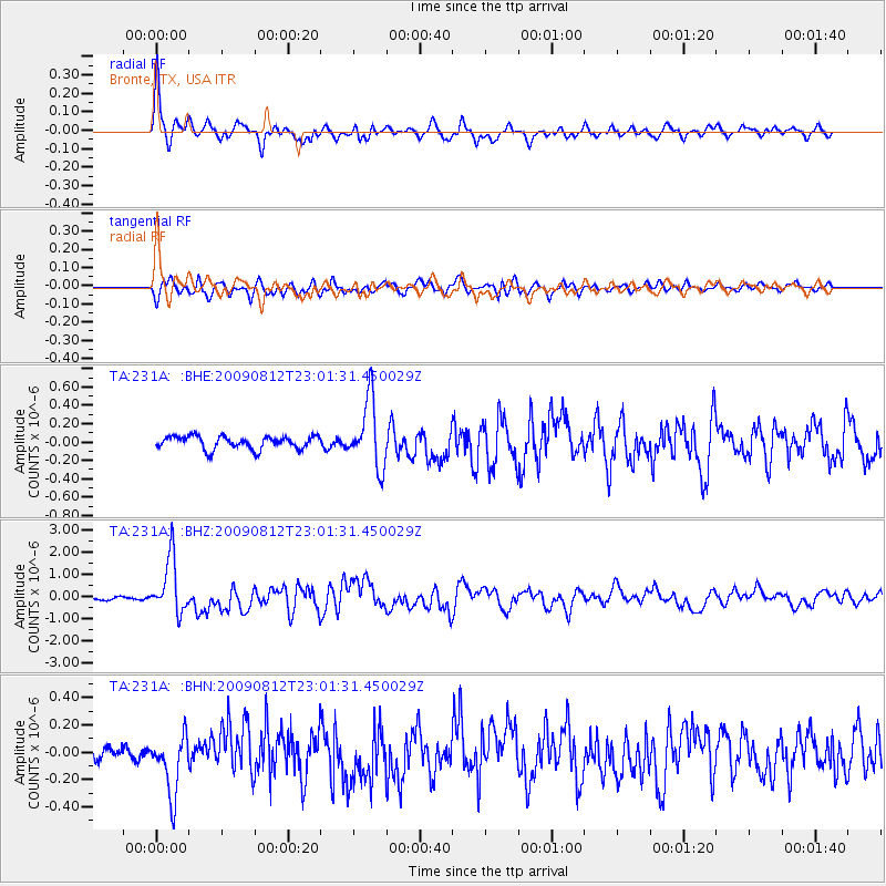
Signal To Noise
| Channel | StoN | STA | LTA |
| TA:231A: :BHZ:20090812T23:01:31.450029Z | 21.12618 | 1.2450265E-6 | 5.893287E-8 |
| TA:231A: :BHN:20090812T23:01:31.450029Z | 3.1303096 | 2.1272847E-7 | 6.795764E-8 |
| TA:231A: :BHE:20090812T23:01:31.450029Z | 5.198891 | 3.6403785E-7 | 7.002221E-8 |
| Arrivals |
| Ps | 3.2 SECOND |
| PpPs | 13 SECOND |
| PsPs/PpSs | 16 SECOND |


