You are here: Home > Network List > TA - USArray Transportable Network (new EarthScope stations) Stations List
> Station D25K Kavik River, AK, USA > Earthquake Result Viewer
D25K Kavik River, AK, USA - Earthquake Result Viewer
| Earthquake location: |
Vanuatu Islands |
| Earthquake latitude/longitude: |
-14.6/167.4 |
| Earthquake time(UTC): |
2017/05/09 (129) 13:52:10 GMT |
| Earthquake Depth: |
169 km |
| Earthquake Magnitude: |
6.8 mww |
| Earthquake Catalog/Contributor: |
NEIC PDE/us |
|
| Network: |
TA USArray Transportable Network (new EarthScope stations) |
| Station: |
D25K Kavik River, AK, USA |
| Lat/Lon: |
69.32 N/146.38 W |
| Elevation: |
770 m |
|
| Distance: |
89.8 deg |
| Az: |
14.867 deg |
| Baz: |
224.375 deg |
| Ray Param: |
0.041683525 |
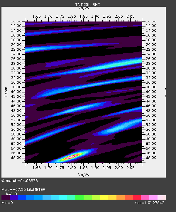
| Estimated Moho Depth: |
67.25 km |
| Estimated Crust Vp/Vs: |
1.80 |
| Assumed Crust Vp: |
6.378 km/s |
| Estimated Crust Vs: |
3.544 km/s |
| Estimated Crust Poisson's Ratio: |
0.28 |
|
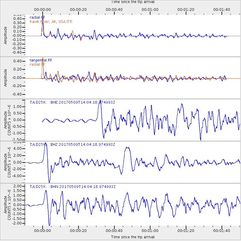
| Radial Match: |
94.95875 % |
| Radial Bump: |
348 |
| Transverse Match: |
85.922134 % |
| Transverse Bump: |
400 |
| SOD ConfigId: |
11737051 |
| Insert Time: |
2019-04-27 08:04:45.106 +0000 |
| GWidth: |
2.5 |
| Max Bumps: |
400 |
| Tol: |
0.001 |
|
Signal To Noise
| Channel | StoN | STA | LTA |
| TA:D25K: :BHZ:20170509T14:04:18.974993Z | 70.55058 | 3.7453767E-6 | 5.308782E-8 |
| TA:D25K: :BHN:20170509T14:04:18.974993Z | 21.284252 | 1.1264476E-6 | 5.292399E-8 |
| TA:D25K: :BHE:20170509T14:04:18.974993Z | 11.499447 | 9.036017E-7 | 7.857784E-8 |
| Arrivals |
| Ps | 8.6 SECOND |
| PpPs | 29 SECOND |
| PsPs/PpSs | 38 SECOND |


