You are here: Home > Network List > TA - USArray Transportable Network (new EarthScope stations) Stations List
> Station L29M Grand Valley Creek, YT, CAN > Earthquake Result Viewer
L29M Grand Valley Creek, YT, CAN - Earthquake Result Viewer
| Earthquake location: |
Vanuatu Islands |
| Earthquake latitude/longitude: |
-14.6/167.4 |
| Earthquake time(UTC): |
2017/05/09 (129) 13:52:10 GMT |
| Earthquake Depth: |
169 km |
| Earthquake Magnitude: |
6.8 mww |
| Earthquake Catalog/Contributor: |
NEIC PDE/us |
|
| Network: |
TA USArray Transportable Network (new EarthScope stations) |
| Station: |
L29M Grand Valley Creek, YT, CAN |
| Lat/Lon: |
63.11 N/138.13 W |
| Elevation: |
918 m |
|
| Distance: |
88.1 deg |
| Az: |
21.738 deg |
| Baz: |
232.05 deg |
| Ray Param: |
0.042429987 |
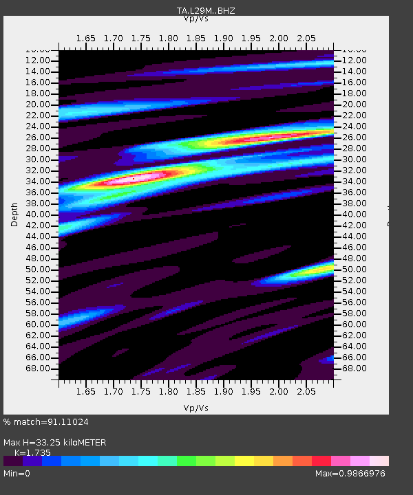
| Estimated Moho Depth: |
33.25 km |
| Estimated Crust Vp/Vs: |
1.74 |
| Assumed Crust Vp: |
6.566 km/s |
| Estimated Crust Vs: |
3.785 km/s |
| Estimated Crust Poisson's Ratio: |
0.25 |
|
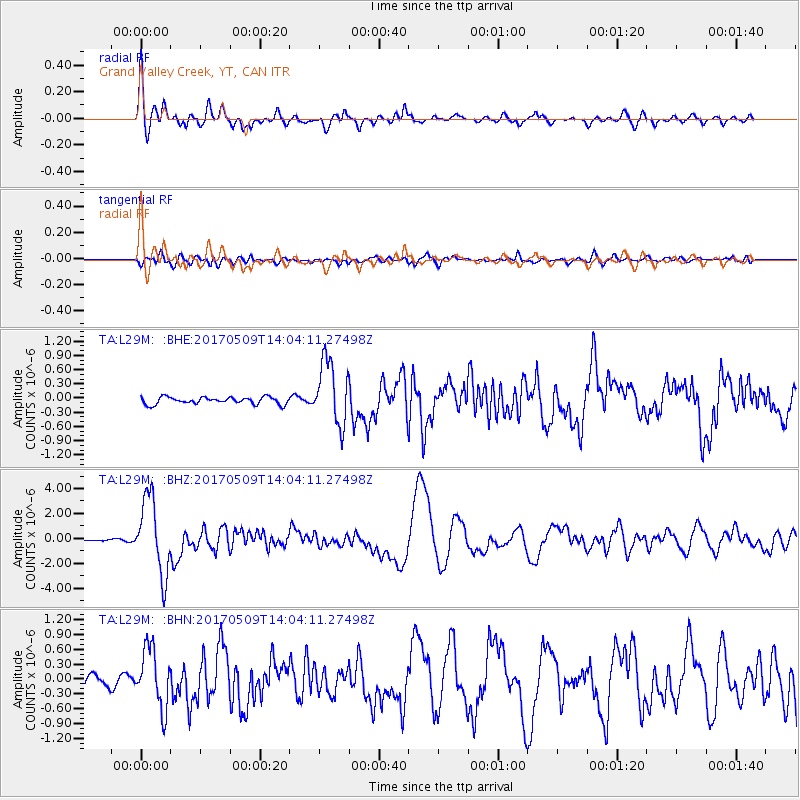
| Radial Match: |
91.11024 % |
| Radial Bump: |
400 |
| Transverse Match: |
74.02181 % |
| Transverse Bump: |
400 |
| SOD ConfigId: |
11737051 |
| Insert Time: |
2019-04-27 08:05:24.428 +0000 |
| GWidth: |
2.5 |
| Max Bumps: |
400 |
| Tol: |
0.001 |
|
Signal To Noise
| Channel | StoN | STA | LTA |
| TA:L29M: :BHZ:20170509T14:04:11.27498Z | 41.379417 | 3.0403355E-6 | 7.347458E-8 |
| TA:L29M: :BHN:20170509T14:04:11.27498Z | 4.8711715 | 6.0040645E-7 | 1.232571E-7 |
| TA:L29M: :BHE:20170509T14:04:11.27498Z | 9.09117 | 6.716574E-7 | 7.388019E-8 |
| Arrivals |
| Ps | 3.8 SECOND |
| PpPs | 14 SECOND |
| PsPs/PpSs | 17 SECOND |


