You are here: Home > Network List > TA - USArray Transportable Network (new EarthScope stations) Stations List
> Station M22K Willow, AK, USA > Earthquake Result Viewer
M22K Willow, AK, USA - Earthquake Result Viewer
| Earthquake location: |
Vanuatu Islands |
| Earthquake latitude/longitude: |
-14.6/167.4 |
| Earthquake time(UTC): |
2017/05/09 (129) 13:52:10 GMT |
| Earthquake Depth: |
169 km |
| Earthquake Magnitude: |
6.8 mww |
| Earthquake Catalog/Contributor: |
NEIC PDE/us |
|
| Network: |
TA USArray Transportable Network (new EarthScope stations) |
| Station: |
M22K Willow, AK, USA |
| Lat/Lon: |
61.75 N/150.12 W |
| Elevation: |
57 m |
|
| Distance: |
83.2 deg |
| Az: |
18.89 deg |
| Baz: |
221.21 deg |
| Ray Param: |
0.045989394 |
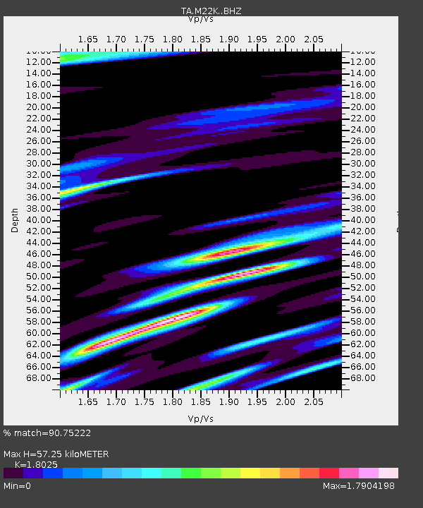
| Estimated Moho Depth: |
57.25 km |
| Estimated Crust Vp/Vs: |
1.80 |
| Assumed Crust Vp: |
6.302 km/s |
| Estimated Crust Vs: |
3.496 km/s |
| Estimated Crust Poisson's Ratio: |
0.28 |
|
| Radial Match: |
90.75222 % |
| Radial Bump: |
400 |
| Transverse Match: |
86.88059 % |
| Transverse Bump: |
400 |
| SOD ConfigId: |
11737051 |
| Insert Time: |
2019-04-27 08:05:27.347 +0000 |
| GWidth: |
2.5 |
| Max Bumps: |
400 |
| Tol: |
0.001 |
|
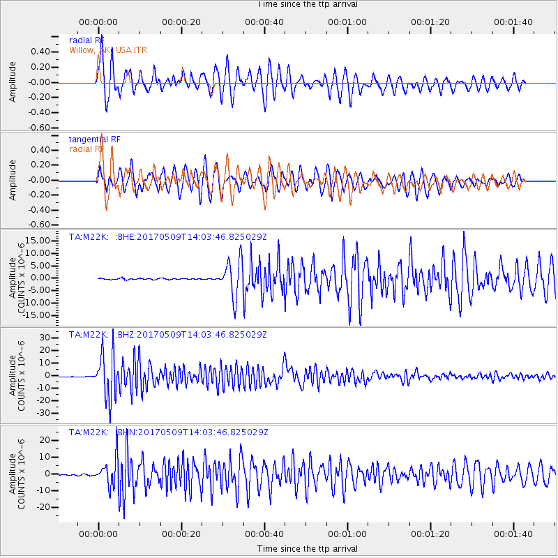
Signal To Noise
| Channel | StoN | STA | LTA |
| TA:M22K: :BHZ:20170509T14:03:46.825029Z | 124.14543 | 1.7579296E-5 | 1.4160244E-7 |
| TA:M22K: :BHN:20170509T14:03:46.825029Z | 37.404694 | 8.7919025E-6 | 2.3504809E-7 |
| TA:M22K: :BHE:20170509T14:03:46.825029Z | 34.868088 | 7.595144E-6 | 2.1782509E-7 |
| Arrivals |
| Ps | 7.5 SECOND |
| PpPs | 25 SECOND |
| PsPs/PpSs | 32 SECOND |


