You are here: Home > Network List > TA - USArray Transportable Network (new EarthScope stations) Stations List
> Station N31M Braeburn, Yukon, CA > Earthquake Result Viewer
N31M Braeburn, Yukon, CA - Earthquake Result Viewer
| Earthquake location: |
Vanuatu Islands |
| Earthquake latitude/longitude: |
-14.6/167.4 |
| Earthquake time(UTC): |
2017/05/09 (129) 13:52:10 GMT |
| Earthquake Depth: |
169 km |
| Earthquake Magnitude: |
6.8 mww |
| Earthquake Catalog/Contributor: |
NEIC PDE/us |
|
| Network: |
TA USArray Transportable Network (new EarthScope stations) |
| Station: |
N31M Braeburn, Yukon, CA |
| Lat/Lon: |
61.49 N/135.78 W |
| Elevation: |
716 m |
|
| Distance: |
88.0 deg |
| Az: |
23.701 deg |
| Baz: |
234.193 deg |
| Ray Param: |
0.042503297 |
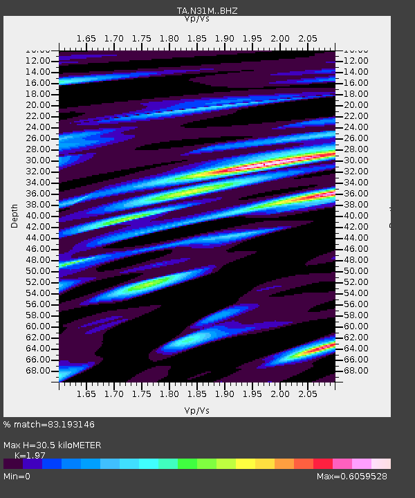
| Estimated Moho Depth: |
30.5 km |
| Estimated Crust Vp/Vs: |
1.97 |
| Assumed Crust Vp: |
6.419 km/s |
| Estimated Crust Vs: |
3.258 km/s |
| Estimated Crust Poisson's Ratio: |
0.33 |
|
| Radial Match: |
83.193146 % |
| Radial Bump: |
400 |
| Transverse Match: |
64.66197 % |
| Transverse Bump: |
400 |
| SOD ConfigId: |
11737051 |
| Insert Time: |
2019-04-27 08:05:38.547 +0000 |
| GWidth: |
2.5 |
| Max Bumps: |
400 |
| Tol: |
0.001 |
|

Signal To Noise
| Channel | StoN | STA | LTA |
| TA:N31M: :BHZ:20170509T14:04:10.800005Z | 19.522154 | 2.797827E-6 | 1.4331549E-7 |
| TA:N31M: :BHN:20170509T14:04:10.800005Z | 3.757931 | 4.7887113E-7 | 1.2742946E-7 |
| TA:N31M: :BHE:20170509T14:04:10.800005Z | 3.8928487 | 7.9216755E-7 | 2.0349302E-7 |
| Arrivals |
| Ps | 4.7 SECOND |
| PpPs | 14 SECOND |
| PsPs/PpSs | 19 SECOND |


