You are here: Home > Network List > CI - Caltech Regional Seismic Network Stations List
> Station MWC Mount Wilson Obsv, Altadena, CA, USA > Earthquake Result Viewer
MWC Mount Wilson Obsv, Altadena, CA, USA - Earthquake Result Viewer
| Earthquake location: |
Colombia |
| Earthquake latitude/longitude: |
3.8/-75.7 |
| Earthquake time(UTC): |
1997/09/02 (245) 12:13:22 GMT |
| Earthquake Depth: |
199 km |
| Earthquake Magnitude: |
6.5 MB, 6.8 UNKNOWN, 6.4 ME |
| Earthquake Catalog/Contributor: |
WHDF/NEIC |
|
| Network: |
CI Caltech Regional Seismic Network |
| Station: |
MWC Mount Wilson Obsv, Altadena, CA, USA |
| Lat/Lon: |
34.22 N/118.06 W |
| Elevation: |
1725 m |
|
| Distance: |
49.6 deg |
| Az: |
312.869 deg |
| Baz: |
118.048 deg |
| Ray Param: |
0.06789612 |
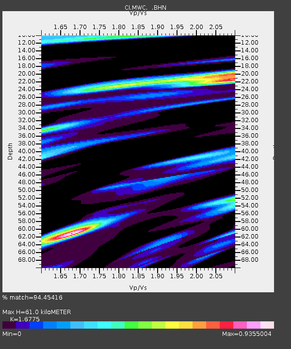
| Estimated Moho Depth: |
61.0 km |
| Estimated Crust Vp/Vs: |
1.68 |
| Assumed Crust Vp: |
6.1 km/s |
| Estimated Crust Vs: |
3.636 km/s |
| Estimated Crust Poisson's Ratio: |
0.22 |
|
| Radial Match: |
94.45416 % |
| Radial Bump: |
302 |
| Transverse Match: |
84.80056 % |
| Transverse Bump: |
400 |
| SOD ConfigId: |
4770 |
| Insert Time: |
2010-02-26 01:10:41.729 +0000 |
| GWidth: |
2.5 |
| Max Bumps: |
400 |
| Tol: |
0.001 |
|

Signal To Noise
| Channel | StoN | STA | LTA |
| CI:MWC: :BHN:19970902T12:21:22.897009Z | 2.1758673 | 2.1124474E-7 | 9.7085305E-8 |
| CI:MWC: :BHE:19970902T12:21:22.897009Z | 1.530611 | 2.1490354E-7 | 1.4040376E-7 |
| CI:MWC: :BHZ:19970902T12:21:22.897009Z | 6.9902587 | 5.6148355E-7 | 8.032371E-8 |
| Arrivals |
| Ps | 7.2 SECOND |
| PpPs | 25 SECOND |
| PsPs/PpSs | 33 SECOND |


