You are here: Home > Network List > TA - USArray Transportable Network (new EarthScope stations) Stations List
> Station O20A White River City, CO, USA > Earthquake Result Viewer
O20A White River City, CO, USA - Earthquake Result Viewer
| Earthquake location: |
Vanuatu Islands |
| Earthquake latitude/longitude: |
-14.6/167.4 |
| Earthquake time(UTC): |
2017/05/09 (129) 13:52:10 GMT |
| Earthquake Depth: |
169 km |
| Earthquake Magnitude: |
6.8 mww |
| Earthquake Catalog/Contributor: |
NEIC PDE/us |
|
| Network: |
TA USArray Transportable Network (new EarthScope stations) |
| Station: |
O20A White River City, CO, USA |
| Lat/Lon: |
40.13 N/108.24 W |
| Elevation: |
1915 m |
|
| Distance: |
95.1 deg |
| Az: |
49.992 deg |
| Baz: |
255.296 deg |
| Ray Param: |
0.040752195 |
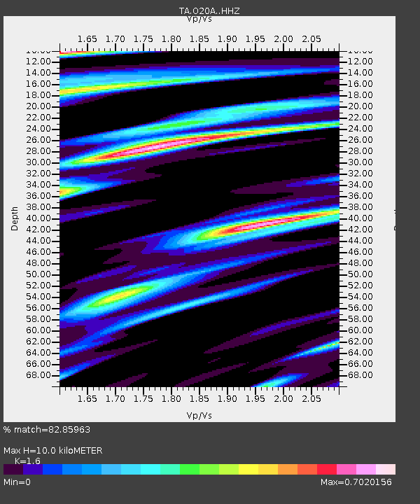
| Estimated Moho Depth: |
10.0 km |
| Estimated Crust Vp/Vs: |
1.60 |
| Assumed Crust Vp: |
6.207 km/s |
| Estimated Crust Vs: |
3.879 km/s |
| Estimated Crust Poisson's Ratio: |
0.18 |
|
| Radial Match: |
82.85963 % |
| Radial Bump: |
400 |
| Transverse Match: |
79.5782 % |
| Transverse Bump: |
400 |
| SOD ConfigId: |
11737051 |
| Insert Time: |
2019-04-27 08:05:43.976 +0000 |
| GWidth: |
2.5 |
| Max Bumps: |
400 |
| Tol: |
0.001 |
|

Signal To Noise
| Channel | StoN | STA | LTA |
| TA:O20A: :HHZ:20170509T14:04:43.14998Z | 12.592259 | 2.6213636E-6 | 2.0817261E-7 |
| TA:O20A: :HHN:20170509T14:04:43.14998Z | 1.1703643 | 1.5800255E-7 | 1.3500288E-7 |
| TA:O20A: :HHE:20170509T14:04:43.14998Z | 3.3999362 | 8.188235E-7 | 2.4083496E-7 |
| Arrivals |
| Ps | 1.0 SECOND |
| PpPs | 4.1 SECOND |
| PsPs/PpSs | 5.1 SECOND |


