You are here: Home > Network List > TA - USArray Transportable Network (new EarthScope stations) Stations List
> Station P17K Kvichak River, AK, USA > Earthquake Result Viewer
P17K Kvichak River, AK, USA - Earthquake Result Viewer
| Earthquake location: |
Vanuatu Islands |
| Earthquake latitude/longitude: |
-14.6/167.4 |
| Earthquake time(UTC): |
2017/05/09 (129) 13:52:10 GMT |
| Earthquake Depth: |
169 km |
| Earthquake Magnitude: |
6.8 mww |
| Earthquake Catalog/Contributor: |
NEIC PDE/us |
|
| Network: |
TA USArray Transportable Network (new EarthScope stations) |
| Station: |
P17K Kvichak River, AK, USA |
| Lat/Lon: |
59.20 N/156.44 W |
| Elevation: |
91 m |
|
| Distance: |
79.2 deg |
| Az: |
18.019 deg |
| Baz: |
215.584 deg |
| Ray Param: |
0.048709765 |
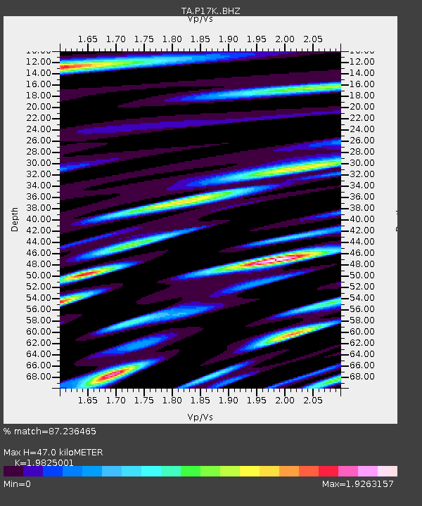
| Estimated Moho Depth: |
47.0 km |
| Estimated Crust Vp/Vs: |
1.98 |
| Assumed Crust Vp: |
6.276 km/s |
| Estimated Crust Vs: |
3.166 km/s |
| Estimated Crust Poisson's Ratio: |
0.33 |
|
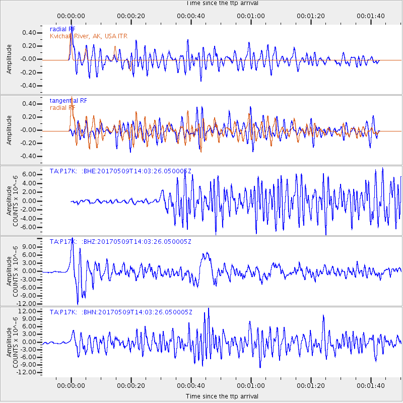
| Radial Match: |
87.236465 % |
| Radial Bump: |
400 |
| Transverse Match: |
76.076584 % |
| Transverse Bump: |
400 |
| SOD ConfigId: |
11737051 |
| Insert Time: |
2019-04-27 08:05:49.411 +0000 |
| GWidth: |
2.5 |
| Max Bumps: |
400 |
| Tol: |
0.001 |
|
Signal To Noise
| Channel | StoN | STA | LTA |
| TA:P17K: :BHZ:20170509T14:03:26.050005Z | 53.28227 | 7.2690154E-6 | 1.3642466E-7 |
| TA:P17K: :BHN:20170509T14:03:26.050005Z | 8.781339 | 2.9399132E-6 | 3.3479103E-7 |
| TA:P17K: :BHE:20170509T14:03:26.050005Z | 7.1074495 | 1.9830672E-6 | 2.790125E-7 |
| Arrivals |
| Ps | 7.5 SECOND |
| PpPs | 22 SECOND |
| PsPs/PpSs | 29 SECOND |


